
Apollo 12 Flag Still Aloft
Copyright © 2012 by Eric M. Jones
All rights reserved.
Last revised 21 April 2012.

| Animation
made from five LROC images of the Apollo 12 landing site,
ordered from sunrise to sunset, and showing the changing
length and location of the shadow cast by the U.S. flag
erected by the crew. The frames are: (1) M131806467LC,
Sun 8 degrees above the eastern horizon; (2) M114104917RC,
32 degrees, east; (3) M137699517LC,
59 degrees, west; (4) M117650516RC,
9 degrees, west; (5) M132983773RC
, 6 degrees, west. LROC images courtesy
NASA/GSFC/Arizona State University. |
The Apollo 12 moon landing occurred on November 19, 1969. The
crew spent 31.5 hours on the lunar surface before returning to lunar
orbit. A U.S. flag was erected early in EVA-1. As
indicated in an overall discussion
of the six flags left on the lunar surface, there are questions as
to whether the flag material has survived 40-plus years in the lunar
environment or whether any of the flag poles had fallen, either
during the Lunar Module liftoff or anytime afterward. This
article resolves this issue for Apollo 12.
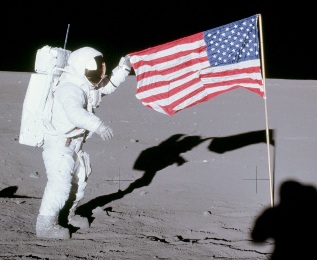
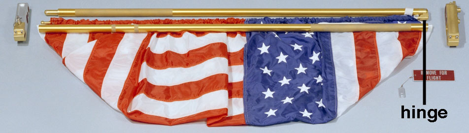
Detail from AS12-47-6896, taken
down-Sun early in EVA-1. A rod is threaded through a
hem sewn at the top of the flag and a latching hinge at the top of
the pole was supposed to hold the flag out perpendicular
to the pole. The latching mechanism failed, so Pete
Conrad is holding the flag out for the camera. (Click on
the image for a larger version.)
|
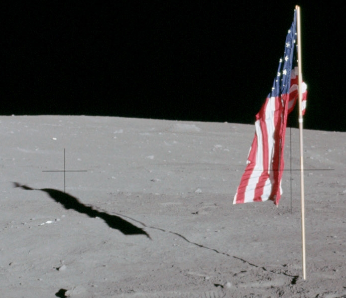
| Detail from AS12-47-6983, taken
late in EVA-1 at about 1455 UTC on November 19,
1969. Anne Platoff's article about the Apollo flags
indicates that the flags were 5 by 3 feet (1.5 by 1.0
meters). Because the supporting rod is hanging
almost vertically, we can estimate that 6.8 feet (2.1
meters) of the pole is above ground and that the bottom of
the flag is about 1.8 feet (0.5 meters) off the ground.
The Sun was 9.2 degrees above the horizon and, on level
ground the shadow would fall in a range from the pole of 3
to 13 meters. |
Detail from AS12-46-6866, taken
at about 16:32 UTC on the 19th, after EVA-1. Solar elevation, 10.0 degrees. Shadow range
from pole on level ground: 2.8 m to 12 m. (Click on the
image for a larger version.)
|
Al Bean told Houston that he hammered
the lower section of the pole about "a foot" into the
ground. The location is marked in Figure 10-50 from the
Apollo 12 Preliminary Science Report. and is about 7 meters out
from the MESA, halfway between the plus-Z (west) and plus-Y
(north) struts.
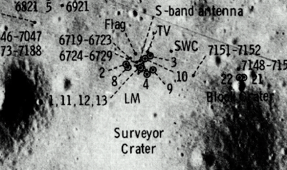
Detail from Preliminary
Science Report Figure 10-50, showing the flag
location. The LM landed rotated clockwise about 10
degrees. The distance between the outer edges of
footpads on opposite sides of the LM is 9.5
meters. The flag is about 12 meters out from the
MESA.
|
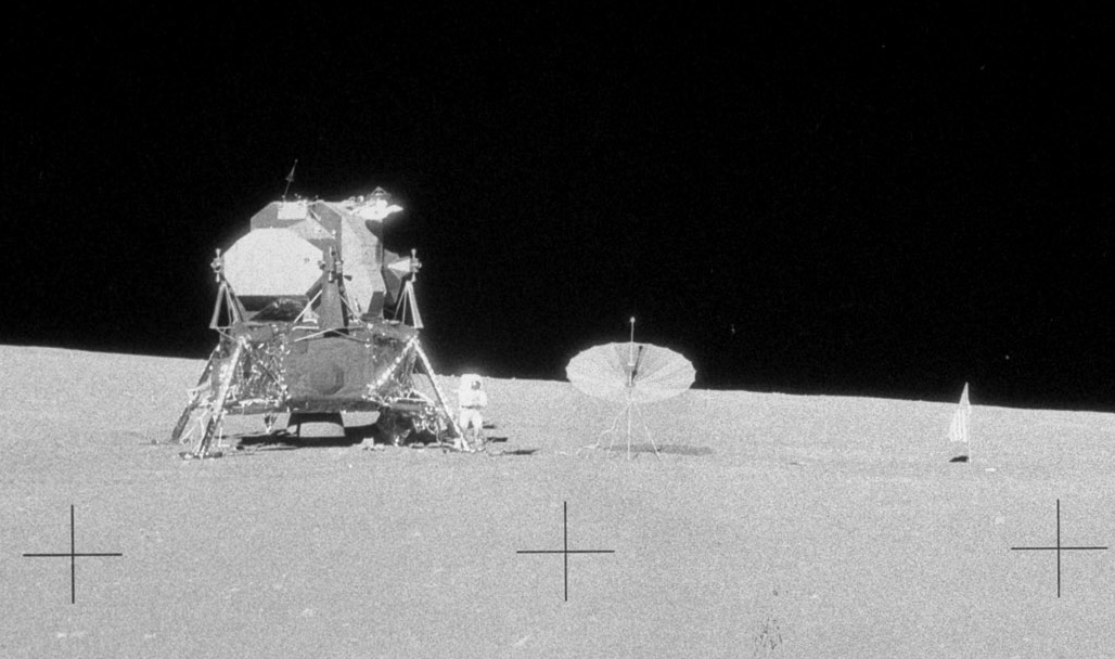
Detail from AS12-48-7152,
taken by Al Bean on his way back to the LM at the end of
the EVA-2 traverse. Pete Conrad went ahead of Bean
to start the close-out. The flag is on the right
and the erectable S-band antenna in the center.
The antenna is connected to the MESA by a 20-foot (6 m)
cable. The dish is 3 meters across and the height
of the supporting tripod is about 2 meters.
|
During Apollo 12 preparations for LM liftoff, the RCS hot-fire
check blew over the S-Band antenna:
140:12:11 Conrad: Here you go,
Houston, with roll, pitch, and yaw (tests of the RCS).
140:12:14 (CapCom Gerry)
Carr: Roger, Pete. (Static; Long Pause)
Intrepid, Houston.
140:12:53 Conrad: (To
Houston) Don't panic! We just blew over our S-band
erectable (with the exhaust from the RCS), and we're up on our
steerable.<p>
140:13:02 Carr:
Roger. I was just going to tell you, Pete, we lost some
of the data on that fire check.
Because
of the tripod attached to the bottom of the dish and the
transmitter mast at the top, the antenna probably ended up on
its side, supported by the ends of two or three ribs and by
either one or two of the tripod legs or the transmitter.
It may well have remained mechanically connected to the MESA by
the cable. Photo
AS12-48-7163
was taken out the LMP's window after EVA-2 and shows most of the
S-band shadow, with the densest part of the shadow cast by the
hardware at the top of the tripod and the converging ribs at the
center of the dish. Further discussion can be found in the
Apollo 14 flag page.
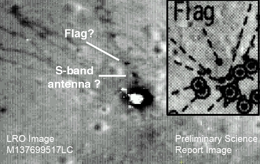
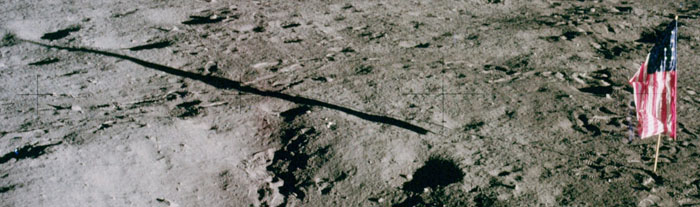
Detail from LROC image taken
with the Sun 59 degrees up from the western horizon.
|
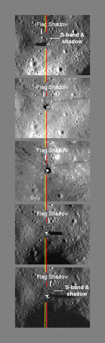
This stack displays the five
LROC images details used to make the animation at the top
of the page. The vertical yellow lines approximate
the east-west location of the flagpole. In the early
morning images at the top of the stack, the flag shadows
start from points west of the flagpole and end farther
west. The situation is reversed for the late
afternoon images at the bottom of the stack. The
vertical red lines approximate the east-west location of
the S-band antenna. With the antenna on its side,
its shadow will be 'attached' to the antenna.
|
What is really being seen in these five
images is the flag shadow itself and not the flag pole
shadow. The flag pole is only about 7/8ths of an inch in
diameter. LRO cameras can at best see down to 0.45 meters (1.5
feet) which is the equivalent to one pixel width in the images and
.55 meters (1.8 feet) which is equivalent to one pixel of
height. This resolution is just good enough to see the
drooped flag shadow (estimated to be from 6 inches to 1.5
feet). Even if the drooped flag is narrower than the .45
meter resolution, since one pixel of the camera’s optics is an
average over an entire area of coverage, the flag’s shadow can
substantially dim a large fraction of this area and, on average,
reduce the pixel illumination even though it cannot blacken it
completely.
The shadows cast by the flag reach
fairly far. The astronauts indicate the Apollo 12 landing
site is fairly flat. If the slope was significant tilted
toward East or West, the shadows would be elongated or shortened
depending on the direction, as would be the case for slight
craters and hills along the shadow path. Assuming the flag
is 2.1 m from the ground to the top of the pole and on a flat
surface, for the near sunrise image (8 degree elevation), the
shadow tip would be 15 meters from the flag pole base (which is
not visible in these images due to the small diameter of the flag
pole); for the near sunset image (6 degree elevation), the shadow
tip would be 20 meters) from the flag pole base. Due to the
unsupported shape of the flag, a precise comparison of predicted
versus actual shadow lengths is not possible, as well as
derivation of flag height from shadow length.
Finally, note that in the morning
images at the top of the LROC stack, the S-band dish shows up as a
bright spot because sunlight reflecting off the mesh. In the
afternoon images, the dish is fainter, suggesting that the tripod
is pointing east and the transmitter mast is pointing west.
