


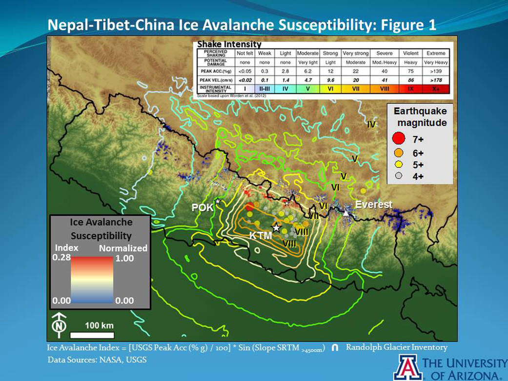


The April 25, 2015, magnitude 7.8 Gorkha earthquake in Nepal violently shook regions of icy peaks and valleys in parts of the high Himalaya closest to the epicenter. The University of Arizona, in collaboration with NASA scientists, produced a map showing the susceptibility of glaciers in Nepal and neighboring Tibet to produce ice avalanches as a result of the quake.
The preliminary map shows the Langtang Valley, for instance, has extremely high ice avalanche susceptibilities due to a combination of elevated shaking levels, very high Himalayan slopes and the presence of glaciers. The Mount Everest area, by contrast, has moderate ice avalanche susceptibilities due to its lower levels of ground surface shaking from the earthquake’s main shock. Both areas produced ice avalanches. The residents of the Langtang area experienced a concentration of large ice and debris avalanches, which corresponds well with the preliminary results found in the ice avalanche susceptibility map. To help focus on the valleys that perhaps are most needing relief, scientists are using the avalanche susceptibility maps together with a database of mountain hazard features (mainly snow avalanches, ice and debris avalanches, rockfalls, landslides and impounded landslide-dammed lakes). Both products are preliminary but show a relationship between potentially hazardous or disastrous mass movements and the shaken, steep, ice-bearing terrain.
The ice avalanche susceptibility map was produced using a known relationship between modeled peak ground accelerations and glacier land surface slopes. Peak acceleration data, expressed as a fraction of Earth’s gravitational acceleration, are from the United States Geological Survey: http://earthquake.usgs.gov/earthquakes/eventpage/us20002926#general_summary .
Slope data are from the Shuttle Radar Topography Mission (SRTM), 295-foot (90-meter) database.
The distribution of glaciers is from the Randolph Glacier Inventory 4.0: http://www.glims.org/RGI/ .
The full-resolution Gorkha Earthquake-Induced Ice Avalanche Susceptibility Map is accessible from the link below as a raster data file for the index, and as high-resolution maps on different bases — the SRTM elevation and the pre-earthquake Landsat 8 photomosaic generated for the earthquake response activity. The map does not portray the relative likelihood of post-earthquake secondary events, as the shaking due to the primary shock is finished. Secondary events will be controlled more by standard landslide and avalanche susceptibilities; local possible large aftershocks may affect the distribution of secondary events.
The three images here are examples from the Gorkha Earthquake-Induced Ice Avalanche Susceptibility Map. Figure 1 includes USGS shake map contour lines and the epicenters of some aftershocks. Figure 2 zooms in on the Langtang area. Figure 3 shows a sample of a mountain hazard feature database combined with avalanche susceptibilities. The mountain hazard database, a work in progress, shows potential hazard features identified by an international team of more than 40 analysts from the United States, Canada, Switzerland, Nepal, The Netherlands and China who are poring over satellite imagery.
To access the data, see:
Landsat 8 base (plus a piece of SRTM):http://web.hwr.arizona.edu/GLIMS/2015-Nepal-Earthquake-Ice-Susc-LS8-UArizona-1000dpi.jpg
SRTM 90-meter gap-filled (v4) color shade base:http://web.hwr.arizona.edu/GLIMS/2015-Nepal-Earthquake-Ice-Susc-SRTM-UArizona-1000dpi.jpg
Zip folder tiff files for gridded ice index (non-normalized):http://web.hwr.arizona.edu/GLIMS/2015-Nepal-Ice-Susceptibility.zip
SRTM base with earthquake-induced ice avalanche susceptibility index and locations of hazard features produced by the Volunteer Team:http://web.hwr.arizona.edu/GLIMS/2015-Nepal-Earthquake-Hazards-Ice-Suscept-SRTM-UArizona.jpg
Image Credit: Base map data: NASA
Jeffrey S. Kargel and Gregory J. Leonard, University of Arizona, Tucson
Contact: Jeffrey Kargel, kargel@hwr.arizona.edu, (520) 780-7759