


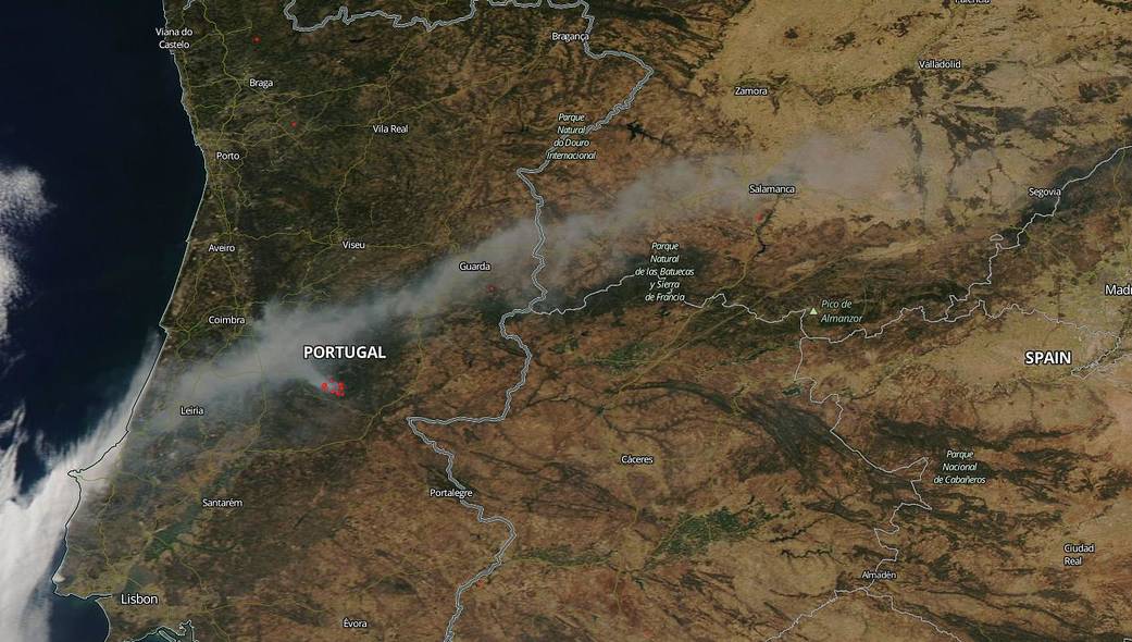
NASA’s Aqua satellite captured this image of an active fire in the Oleiros municipality of Portugal on July 26, 2020. The cause of the blaze is under investigation. Three factors that are needed for fire outbreaks and spread are heat, wind and fuel. As a nation on Europe’s southwestern side, the warm, well-forested country has consistent warm winds coming off the Atlantic. This makes Portugal a target for wildfires and the country that has the one of the highest number of wildfire outbreaks in the European Union.
The fire, which began Saturday, July 25, is in the municipality of Oleiros and has spread to the neighboring municipalities of Sertã and Proença-a-Nova, in the Castelo Branco district, and is now being fought by more than 700 operatives and supported by 14 aerial units. This fire is, as of today July 27, the largest firefighting operation in the country. Winds are carrying the smoke from the fire into Spain as far east as Segovia–a distance of 235 miles.
Portugal has experienced devastating wildfires in recent years. In 2017, Portugal experienced a particularly bad fire season with one fire that swept through the center of the country killing 66 people. Six regions in central and southern Portugal are currently on high alert for fires. On Sunday, July 26, the Portuguese Government declared an “alert situation” due to the fire risks in the interior of the country. This included a ban on all rural fires. A map found on the IPMA website (Portuguese Institute for Sea and Atmosphere) shows the area on fire as having the “highest risk” of wildfire outbreak.
NASA’s satellite instruments are often the first to detect wildfires burning in remote regions, and the locations of new fires are sent directly to land managers worldwide within hours of the satellite overpass. Together, NASA instruments detect actively burning fires, track the transport of smoke from fires, provide information for fire management, and map the extent of changes to ecosystems, based on the extent and severity of burn scars. NASA has a fleet of Earth-observing instruments, many of which contribute to our understanding of fire in the Earth system. Satellites in orbit around the poles provide observations of the entire planet several times per day, whereas satellites in a geostationary orbit provide coarse-resolution imagery of fires, smoke and clouds every five to 15 minutes. For more information visit: https://www.nasa.gov/mission_pages/fires/main/missions/index.html
NASA’s Earth Observing System Data and Information System (EOSDIS) Worldview application provides the capability to interactively browse over 700 global, full-resolution satellite imagery layers and then download the underlying data. Many of the available imagery layers are updated within three hours of observation, essentially showing the entire Earth as it looks “right now.” Actively burning fires, detected by thermal bands, are shown as red points. Image Courtesy: NASA Worldview, Earth Observing System Data and Information System (EOSDIS). Caption: Lynn Jenner and the Republica Portuguesa website and the Jornal Economico.