


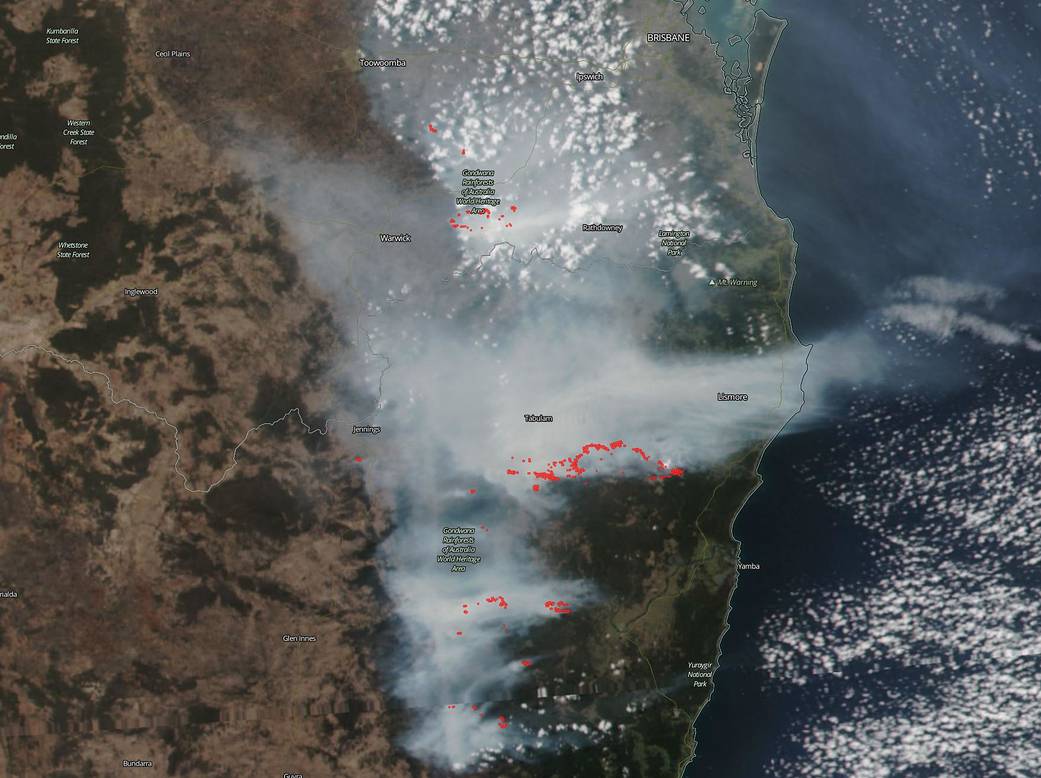
Fires burning in southeastern Queensland and northeastern New South Wales on Oct. 9, 2019, were generating a lot of smoke that was visible by satellite.
NASA/NOAA’s Suomi NPP satellite captured this image of smoke in. Some of the fires were burning near the border of Queensland and New South Wales around the vicinity of the Lamington National Park on the Queensland side of the border. Fires and smoke were also detected in the Gondwana Rainforests which are found in both Queensland and New South Wales.
NASA/NOAA’s Suomi NPP satellite gathered visible and infrared data on the regions using the VIIRS instrument (Visible Infrared Imaging Radiometer Suite). Actively burning fires, detected by thermal bands on the instrument are shown as red points
The Lamington National Park is known for a section of the ancient Gondwana Rainforests and is the home to the rare Albert’s lyrebird. On October 10, 2019, the Parks and Forest area in the Department of Environment and Science (PFDES) in the Queensland Government reported that the Binna Burra section is closed due to wildfire. This alert applies to the following parks: Gold Coast Hinterland Great Walk and the Lamington National Park. The PDFES website noted, “As a result of damage due to wildfire, the Binna Burra section of Lamington National Park is temporarily closed until declared safe. QPWS rangers are currently working on repairs. Observe all signage, barriers and directions from rangers, and do not enter closed areas.”
The Gondwana Rainforests, extending from Queensland into New South Wales are also a World Heritage Area. According to the New South Wales National Parks and Wildlife Service. “The rainforests are the most extensive areas of subtropical rainforest in the world, large areas of warm temperate rainforest, and the majority of the world’s Antarctic beech cool temperature rainforest. These extraordinary areas still contain ancient and primitive plants and animals.”
NASA’s Earth Observing System Data and Information System (EOSDIS) Worldview application provides the capability to interactively browse over 700 global, full-resolution satellite imagery layers and then download the underlying data. Many of the available imagery layers are updated within three hours of observation, essentially showing the entire Earth as it looks “right now.” Suomi NPP is managed by NASA and NOAA.
Image Courtesy: NASA Worldview, Earth Observing System Data and Information System (EOSDIS). Caption: Rob Gutro, NASA’s Goddard Space Flight Center, Greenbelt, Md.