


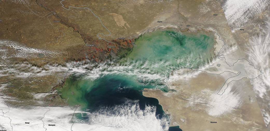
NASA’s Aqua satellite captured this image of the Volga Delta in Russia and the fires surrounding the area on March 15, 2019. In 2003 the Earth Observatory (EO) also spotted the same type of fire incident on March 31 of that year. In that posting EO reported: “In southwestern Russia, snow has retreated from the brown landscape, and farmers are preparing land for the spring planting. This Moderate Resolution Imaging Spectroradiometer (MODIS) image (below) from March 31, 2003, shows scattered fires marked with red dots. Fires are concentrated in the fan-shaped Volga River Delta at right and all along the foothills of the Caucasus Mountains at bottom). Ice persists in the northeastern corner of the Caspian Sea (right edge), while ice-free coastal waters swirl with colors that indicate a bloom of aquatic plant life.”
Most interestingly, if you compare the image from 2003 with this image from March 15, 2019, the one stark difference is the loss of the ice in the northeastern corner of the Caspian Sea. This image, taken two weeks earlier in this calendar year, shows that the ice has already melted in that area. The bloom of aquatic life discussed in the 2003 image is much more prevalent in this 2019 image meaning the waters area already warmer than they were on March 31, 2003.
The fires that ring the 2019 image and the 2003 image are both from the same source, farmers setting their lands on fire to prepare for the upcoming planting season. Certain things never change from year to year like agricultural processes worldwide.
NASA’s Earth Observing System Data and Information System (EOSDIS) Worldview application provides the capability to interactively browse over 700 global, full-resolution satellite imagery layers and then download the underlying data. Many of the available imagery layers are updated within three hours of observation, essentially showing the entire Earth as it looks “right now.” Actively burning fires, detected by thermal bands, are shown as red points. Image Courtesy: NASA Worldview, Earth Observing System Data and Information System (EOSDIS). Caption: Lynn Jenner with information from a 2003 Earth Observatory posting.
