


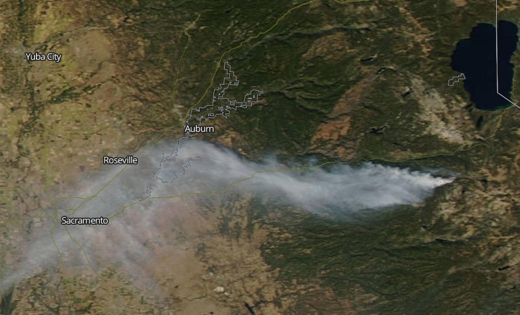
A fire in the Eldorado National Forest generated a large plume of smoke that stretched from southwest of Lake Tahoe to over 100 miles west, reaching Sacramento, California.
This natural-color satellite image was collected by the Moderate Resolution Imaging Spectroradiometer (MODIS) aboard the Aqua satellite on Oct. 10, 2019. Actively burning fires, detected by thermal bands show “heat signatures” or indications of fire and are shown as red points. The image showed that the fire, known as the Caples Fire, was located in the Eldorado National Forest, located in east central California, not too far from Lake Tahoe. The MODIS image showed a thick plume of light brown smoke stretching more than 100 miles west to Sacramento, Calif.
On Oct. 7, the Eldorado National Forest issued a release about the prescribed burning activity that was expected to generate smoke. The release said, “Fire management staff are continuing to burn along the northern ridge above Caples Creek as part of a multi-year 8,800 acre prescribed fire within the Caples Ecological Restoration Project. More smoke is expected over the next several days and will generally be heavier in the morning after the air cools and settles at night. The Caples Prescribed Fire is at 7,500 feet in elevation. Conditions in the project area are cooler and more moist than the area below 6,000 feet where a red flag warning is in effect for Tuesday evening through Thursday. Although the recent snow has melted, fuel moistures continue to be above normal and the Caples Prescribed Fire is burning slowly in dead and dry fuels, successfully meeting the fuel reduction objectives of the project.”
On Oct. 11 at 12 a.m. EDT (Oct. 10 at 9 p.m. PDT), the U.S. Forest Service’s Eldorado National Forest in Placerville, Calif. noted, “The Caples prescribed burn was declared a wildland fire on October 10 at approximately 1:30 p.m. PDT. Fire managers made the decision due to unfavorable weather conditions and the inability to meet previously established objectives. This change allows for additional resources to assist in suppression from partners such as CalFire.”
“The Caples prescribed burn began as pile burning 10 days ago under favorable conditions following rain and snowstorms. This is part of a larger, multi-year forest restoration project. The goal of this project is to promote a healthy resilient forest by reintroducing fire to the landscape. In anticipation of the upcoming strong winds, fire managers began building fireline and conducting firing operations to secure the fire perimeter. Unfavorable conditions over the past few days prevented crews from being able to complete the firing operations contributed to the incident being declared a wildland fire.”
For updates on California fires, visit the California Department of Forestry and Fire Protection website: https://www.fire.ca.gov/incidents
NASA’s Earth Observing System Data and Information System (EOSDIS) Worldview application provides the capability to interactively browse over 700 global, full-resolution satellite imagery layers and then download the underlying data. Many of the available imagery layers are updated within three hours of observation, essentially showing the entire Earth as it looks “right now.”
Image Courtesy: NASA Worldview, Earth Observing System Data and Information System (EOSDIS). Caption: Rob Gutro, NASA’s Goddard Space Flight Center, Greenbelt, Md., with information from Inciweb.