


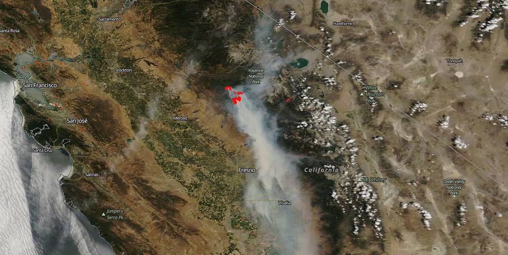
The Ferguson fire located outside of Yosemite National Park has been raging since July 13, 2018. And it is still causing multiple issues for residents of the area and firefighters alike. Yosemite National Park officials announced closures to the Yosemite Valley and Wawona areas, as well as the Mariposa Grove of Giant Sequoias, effective noon on Wednesday, July 25. Yosemite National Park continues to experience high fire danger, along with continued hot and dry weather patterns. The Ferguson fire grew by 1,723 acres overnight to a total of 43,299 acres. A total of 3,686 personnel are currently engaged in fighting the fire. There has been 1 fatality and 7 injuries to date. 1 structure has been destroyed. There are many mandatory evacuations in place and these can be found by going to the Inciweb page for the fire.
What is also causing issues and elevated concerns is the amount of smoke that is being produced by the blaze. The satellite image shows a huge smoke trail that leads south from the fire all the way to Bakersfield which is 170 miles away. The Wildland Fire Air Quality Response Program is forecasting unhealthy air quality for the areas around Yosemite and Southern Sierra. The air quality ranges from moderate levels of particulates for those areas farther away from the smoke to Unhealthy and Very Unhealthy cautioning those most sensitive to stay indoors. The smoke released by any type of fire (forest, brush, crop, structure, tires, waste or wood burning) is a mixture of particles and chemicals produced by incomplete burning of carbon-containing materials. All smoke contains carbon monoxide, carbon dioxide and particulate matter (PM or soot). Smoke can contain many different chemicals, including aldehydes, acid gases, sulfur dioxide, nitrogen oxides, polycyclic aromatic hydrocarbons (PAHs), benzene, toluene, styrene, metals and dioxins. The type and amount of particles and chemicals in smoke varies depending on what is burning, how much oxygen is available, and the burn temperature.
NASA’s EOSDIS provides the capability to interactively browse over 600 global, full-resolution satellite imagery layers and then download the underlying data. Many of the available imagery layers are updated within three hours of observation, essentially showing the entire Earth as it looks “right now”. This natural-color satellite image was collected on July 25, 2018. Actively burning areas, detected by thermal bands, are outlined in red. NASA image courtesy NASA/Goddard Space Flight Center Earth Science Data and Information System (ESDIS) project. Caption: Lynn Jenner with information from Inciweb.