


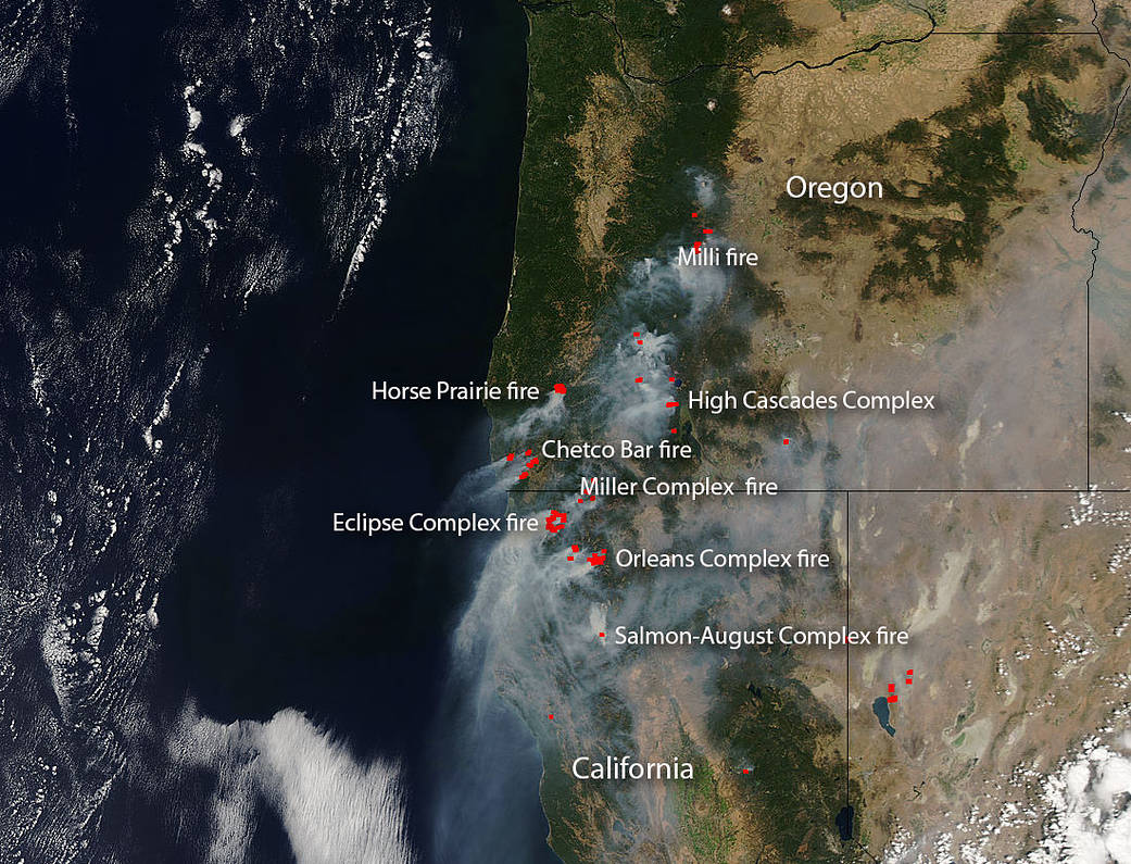
Seven fire complexes (fires made up of several fires coming together and forming a complex) and one fire are seen in this image (with a couple of other fires seen but not noted on the image.)
In Oregon after a rainy, cool spring, the summer has brought little rainfall causing dry conditions. As the dry conditions escalated during the summer Oregon governor declared a state of emergency with respect to wildfires. In this image four distinct wildfire complexes (as well as several others not labeled) are seen as red marks which denotes areas of high temperatures. When accompanied by smoke, as these are, it is diagnostic for fire.
The Chetco Bar Fire began as a lighting strike on July 12. At present this fire located in the Rogue River-Siskiyou National Forest is 131,197 acres in size and 10% contained. Conditions in the area are not conducive to fire containment as a Red Flag Warning is in effect for the Chetco Bar Fire area through Friday evening (9/1) for strong, gusty, northeast winds and low humidity through Friday morning, followed by very hot, dry and unstable conditions Friday (9/1) afternoon and evening.
The High Cascades Complex which began on Aug. 13 with a lightning strike is currently 26,332 acres in size and is 37% contained. The fire is located in Rogue River-Siskiyou and Crater Lake National Park. The High Cascades Complex consists of 20 fires–15 are originally part of the High Cascades Complex and 3 are originally part of the Falcon Complex. Thirteen of these fires have been contained and are in patrol status. The remaining seven are being managed with a full suppression strategy. There will be a return to hot. dry conditions over the weekend (9/1) exacerbating fire conditions and making the fires harder to contain.
The Horse Prairie Fire began on Aug. 26 and its cause is currently under investigation. This fire has grown to 11,500 acres. The Horse Prairie Fire is burning on both private industrial forest lands and Bureau of Land Management forest lands. While the fire is not a threat to homes, it has destroyed some logging equipment in the area.
The Milli Fire is located nine miles west of Sisters, Oregon in the Three Sisters Wilderness. This fire began on Aug. 11 with a lightning strike. The size of the fire is 22,467 acres and is 44% contained at present. Once again weather is allowing the fire to spread due unseasonably hot, dry conditions and wind gusts. The Milli fire is forcing evacuations in the area.
California is not exempt from this active fire season and in this Aqua image, four separate large fire complexes are labeled. One complex began in Oregon and burned southward into California. This complex, the Miller Fire complex, is currently 14,939 acres in size and is 44% contained. The fires began on Aug. 14 as a line of thunderstorms rolled across the region and lightning strikes ignited 25 wildfires. Crews attacked them, one at a time, trying to get as many as they could completely out. The remainder that were not contained were combined into the Miller Complex. Within the Miller Complex, 25 fires have been tracked since August 14. While all 25 fires continue to be monitored, only 6 of the fires are experiencing growth: Creedence Fire, Bigelow Fire, Burnt Peak Fire, Seattle Fire, Abney Fire, and Cook Fire. A large number of evacuations are in effect around the areas that are still spreading. Weather conditions continue to be an issue for fire growth. A Red Flag warning for poor humidity recoveries and gusty east to northeast winds were in effect Thursday night (8/31) and will be into Friday morning. Heat will begin to build again Friday afternoon and through the weekend.
The Eclipse Complex fire began on Aug 15 as a line of thunderstorms hit and lightning strikes ignited a series of wildfires that have been corralled into this complex. Its current size is 76,100 acres and it is 25% contained. Due to continued northeast winds and very low relative humidity recovery overnight (8/31), active portions of the fires continued burning through the evening. Excessive heat, as in all the other areas, is cause for concern as well accompanying gusty winds that spread fire quickly. Communities along the Klamath River are also experiencing degraded air quality. The smoke is also limiting visibility on forest roads and state highways.
The Orleans complex which began on July 25 with a lightning strike is currently 14,445 acres in size and is 51% contained. The Orleans Complex is comprised of nineteen fires, three of which remain active. The Ukonom Fire is 4,195 acres and is 52% contained. The Haypress Fire is 8,520 acres and 0% contained. The Burney Fire is 1,395 acres and 0% contained. Weather conditions are extreme here as well causing hot, dry temperatures and strong ridgetop winds. Gusty northeast winds are expected to continue into this afternoon (9/1), then switch to the more typical northerly winds. Poor air quality is expected to impact communities for the next several days.
The Salmon-August complex started on Aug. 11 when a thunderstorm rolled through producing multiple lightning strikes which ignited the fires. This complex of fires has grown to over 21,625 acres. Fire crews on the ground combined with air resources are aggressively working to contain the Wallow Fire, which is 19,512 acres. This complex of fires consists of seven different fires although Wallow is by far the largest of the group. Wallow is the only truly active fire left with only 19% containment. All other fires are much smaller and are mostly contained. Residents within Siskiyou County can expect to see smoke for the next several days from this complex and surrounding fires. This area is also under a Red Flag warning and conditions of high temps, low humidity and high winds are all indicators that the fire will spread.
NASA’s Aqua satellite collected this natural-color image with the Moderate Resolution Imaging Spectroradiometer, MODIS, instrument on August 31, 2017. Actively burning areas (hot spots), detected by MODIS’s thermal bands, are outlined in red. Each hot spot is an area where the thermal detectors on the MODIS instrument recognized temperatures higher than background. When accompanied by plumes of smoke, as in this image, such hot spots are diagnostic for fire. NASA image courtesy Jeff Schmaltz LANCE/EOSDIS MODIS Rapid Response Team, GSFC. Caption by Lynn Jenner with information from Inciweb.