


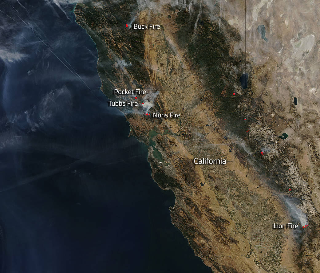
Northern parts of California especially around the Napa and Sonoma Valley areas are still having major wildfire issues that continue to be exacerbated by weather conditions. Other areas of California are also in danger, though, due to other fires both north and south of the Santa Rosa area fires.
The Santa Rosa area has indeed been decimated by the fires and on this Aqua satellite image, three of the fires can clearly be seen still burning. The Pocket, Tubbs and Nuns fire are all still causing havoc in the area. The Pocket fire in Geyserville is 11,889 acres and is 40% contained. The fire continues to progress to the north with crews continuing to make progress and increase containment. The Tubbs fire has burned 36,390 acres and is 70% contained. The most active portion of the fire is still the northeastern portion around Red Hill and Mount Saint Helena. The fire continues to make short uphill runs around to the north side of the peaks. The acreage of the fire has decreased based on the completion of more accurate and detailed mapping. The Nuns fire is 48,627 acres and is 50% contained. It is progressing to the north and spreading at a moderate rate driven by steep slopes and dry fuel. These fires together and including the Oakmont fire have resulted in 22 deaths, 3,947 structures destroyed, and 159 structures damaged. Total acres in the area that have been affected: 97,781 acres.
North of these fires is the Buck Fire in the Mendocino National Forest. This fire began on September 12, 2017 as the result of a lightning strike near Black Rock Mountain, close to the Yolla-Bolly Middle Eel Wilderness. Fire activity has increased due to wind and continued dry weather and fuels, and fire has spread south into the Yolla Bolla-Middle Eel Wilderness. A total of 10,450 acres has burned as of October 12, 2017. The fire is 68% contained.
South of the Santa Rosa fires is a wildfire in the Sequoia National Forest named the Lion Fire. This fire began on September 24, 2017 with a lightning strike. Currently the fires is at 16,800 acres. The plan is to continue with defensive firing (aerial and hand) along the Lion Meadow trail west toward Burnt Corral until the fire is secured. The smoke from the fire is intense at times and smoke forecasts for this fire can be found here: www.valleyair.org
NASA’s Aqua satellite collected this natural-color image with the Moderate Resolution Imaging Spectroradiometer, MODIS, instrument on October 15, 2017. Actively burning areas (hot spots), detected by MODIS’s thermal bands, are outlined in red. Each hot spot is an area where the thermal detectors on the MODIS instrument recognized temperatures higher than background. When accompanied by plumes of smoke, as in this image, such hot spots are diagnostic for fire.NASA image courtesy Jeff Schmaltz LANCE/EOSDIS MODIS Rapid Response Team, GSFC. Caption by Lynn Jenner with information from the CA fire website and Inciweb.