


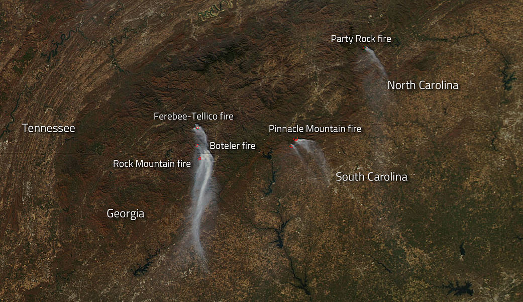
NASA’s Aqua satellite captured this image, using its MODIS instrument, of several wildfires still plaguing the southeastern United States on November 26, 2016. There are four fires identified in this image, however, there are many others still raging on whose smoke or heat signatures were not picked up on this particular satellite pass. The fires identified here are the Rock Mountain fire in Georgia, the Pinnacle Mountain fire in South Carolina, and the Party Rock, Boteler and Ferebee-Tellico fires in North Carolina. There are other fires that have been reported recently near Gatlinburg, Tennessee, but this satellite image does not show those fires.
The Rock Mountain fire has been underway since November 09, 2016. Currently the fire has affected 24,725 acres and is now 50% contained. The fire was human caused and the origins of that fire are now being investigated. Expected rain should continue through Tuesday, Nov. 29, bringing approximately three quarters of an inch of precipitation to this area currently undergoing an extreme drought. Isolated thunderstorms are possible Tuesday afternoon.
The Pinnacle Mountain fire in South Carolina also began on November 09, 2016. This fire was also human caused and has now affected 10,560 acres. The Pinnacle Mountain fire is 62% contained at present. Showers are currently bringing needed moisture to the area, but those showers are predicted to end around midday on Tuesday the 29th, however more showers are expected to develop Tuesday night. Total rainfall in the area could exceed 2 inches.
The three fires in North Carolina are the Party Rock, Boteler, and Ferebee-Tellico fires. The Party Rock fire began on November 05 and the cause of the wildfire is still being investigated. The fire has affected 7,142 acres and firefighters have completely contained the fire at this point. A State of Emergency is in effect for western North Carolina due to the ongoing wildfires. Boteler fire began on October 25 and the cause of the fire is unknown. The fire has burned 9,036 acres at present and firefighters have contained the fire 85% at present. Mild temperatures in the 60s combined with high humidity and approaching rainfall have minimized fire weather conditions. More rain is expected in this area with at least two different rounds of rain expected by late Wednesday night. The Ferebee fire joined with the Tellico fire and fire officials are now calling the joined fire the Tellico fire. The Ferebee fire began on November 06 and the cause of the wildfire is unknown. To date the fire has affected 13,874 (combined with the Tellico fire). Fire officials have this combined fire 95% contained. As with the Boteler fire which is in close proximity, the weather is helping to quell the flames with high humidity and rain coming into the area.
NASA’s Aqua satellite collected this natural-color image with the Moderate Resolution Imaging Spectroradiometer, MODIS, instrument on November 26, 2016. Actively burning areas, detected by MODIS’s thermal bands, are outlined in red. NASA image courtesy Jeff Schmaltz LANCE/EOSDIS MODIS Rapid Response Team, GSFC. Caption by Lynn Jenner with information from Inciweb.