


NASA Embarks on a Sweeping Airborne Science Expedition
March 3, 2004
Release: 04-09
An international team of scientists from NASA and other research institutions has embarked on a three-week expedition of discovery that will take them from the lush, dense rain forests of Central America to the frigid isolation of Antarctica.
Armed with a unique radar instrument, the team will survey selected sites in Central America to help unearth archaeological secrets and preserve resources, biological and cultural diversity. Then the scientists are off to South America’s Patagonian ice fields and Antarctica to conduct topographic surveys to better gauge the effect of climate change in that region.
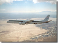
The team’s savvy tour guide is an all-weather imaging tool, the Airborne Synthetic Aperture Radar (AirSAR), developed and managed by NASA’s Jet Propulsion Laboratory, Pasadena, Calif. Carried aboard a NASA DC-8 Airborne Science laboratory, AirSAR can penetrate clouds and also collect data at night. Its high-resolution sensors operate at multiple wavelengths, polarizations and in interferometric modes. This means AirSAR “sees” beneath treetops, through thin sand, and dry snow pack. The sensors can produce topographic models. The highly-modified aircraft departed NASA’s Dryden Flight Research Center at Edwards March 1, bound for southern Mexico and Central America.
“Central America’s unique environment and irreplaceable archaeology are being altered and destroyed at an alarming rate,” said Dr. Ghassem Asrar, NASA Associate Administrator for Earth Science. “Natural and cultural resources may disappear unless accurately inventoried. NASA’s AirSAR campaign provides unique data not available from other space borne or commercial observational platforms that will help scientists characterize past and present human impacts on the landscape. Meanwhile, in South America and Antarctica, AirSAR will enable better assessments of how climate change is impacting glaciers and ice shelves and contributing to sea level rise.”
Much of the archaeological evidence needed to understand Pre-Columbian societies in Central America comes from identifying and documenting features remaining on the landscape. Difficult terrain and logistics have limited ground-data collection. Previous remote sensing techniques were unable to penetrate the forest canopy. AirSAR is expected to detect features such as fortifications, causeways, walls and other evidence of advanced civilizations hidden beneath the forest. Images will shed insight into how modern humans interact with their landscape, how ancient peoples lived and what became of them. AirSAR’s archaeological applications were first demonstrated at Angkor, Cambodia, in 1996. It provided better detail than radar images obtained from a previous Space Shuttle flight.
The team will continue on to Chile to survey Patagonian ice fields and the Antarctic Peninsula, where AirSar will collect imagery and high-precision topography data to help determine the contribution of southern hemisphere glaciers to sea level rise due to climate change. In Patagonia, a recent study by NASA and others found the contribution more than doubled from 1995 to 2000, compared to the previous 25 years. AirSAR will make it possible to determine whether that trend is continuing or accelerating.
Not much is known about the poorly mapped glaciers in the Antarctic Peninsula, an area 10 times larger than Patagonia. The area recently experienced rapid atmospheric warming, triggering a widespread retreat of floating ice shelves, reducing permanent snow cover and lengthening the melt season. AirSAR will provide reliable information on ice shelf thickness to measure the contribution of the glaciers to sea level rise. It will also provide a precise topographic reference for comparison with satellite laser-altimetry data from NASA’s Icesat satellite and previous airborne data.
AirSAR’s scientific mission would not be possible without NASA’s unique DC-8 flying laboratory, a converted jetliner that has flown hundreds of Earth science payloads.
“NASA Dryden has provided the international science community with this heavy-lift airborne laboratory and its flight crew, engineering staff, ground and maintenance personnel and support staff, capable of flying virtually anywhere,” said NASA Dryden DC-8 mission manager Walter Klein.
AirSAR’s 2004 campaign is a collaboration of many U.S. and Central American institutions and scientists, including NASA; the National Science Foundation; the Smithsonian Institute; National Geographic; Conservation International; the Organization of Tropical Studies; the Central American Commission for Environment and Development; and the Inter-American Development Bank.
For information about AirSAR on the Internet, visit: http://airsar.jpl.nasa.gov and /centers/dfrc/Research/AirSci/index2.html
New photos of NASA’s DC-8 flying laboratory can be downloaded at: /centers/dfrc/Gallery/Photo/DC-8/index.html
New video footage of the DC-8 flying laboratory is available to media by contacting Beth Hagenauer at (661) 276-7960.
-NASA-