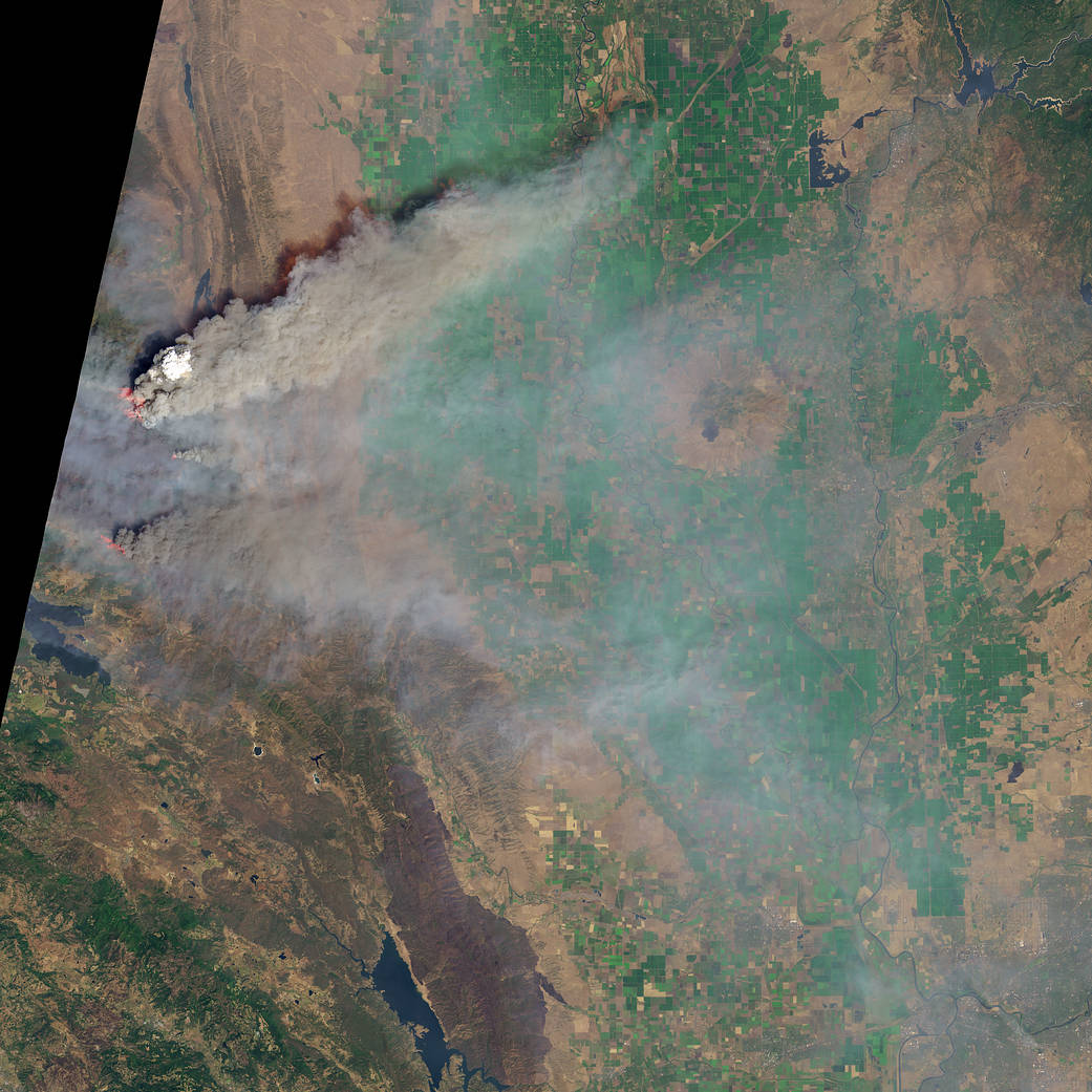
On August 6, 2018, the Operational Land Imager (OLI) on Landsat 8 captured this image of a dense column of smoke topped by a pyrocumulus cloud over the Ranch fire.
In July and August 2018, towering plumes of smoke have risen from several fires in northern California. Though heavy rains ended the lengthy drought that parched California, trees and vegetation killed during that dry spell still linger in California’s forests. With all that extra fuel priming the state’s forests for large fires, a period of hot and windy weather this summer made it extremely difficult for firefighters to maintain the upper hand.
One of the fires—the Mendocino Complex—surpassed the 2017 Thomas fire to become California’s largest fire on record. As of August 7, 2018, the fire had charred 1,200 square kilometers (460 square miles), an area about the size of New York City. Another blaze, the Carr fire near Redding, had torched more than 1,000 homes, making it California’s sixth most destructive fire on record. Several thousand firefighters are battling each of the large fires in California.
The heat generated by intense wildfires can churn up towering pyrocumulus and pyrocumulonimbus clouds, which lift smoke above the boundary layer, the lowest part of the atmosphere. “The hotter a fire burns, the higher up smoke can go, and the farther it can spread,” explained Amber Soja, an atmospheric scientist at NASA’s Langley Research Center.
Smoke injected above the boundary layer often travels hundreds or thousands of kilometers away from the source before descending. Satellites have observed smoke from the California fires spreading into nearly two dozen states, though the highest concentrations were found in California and the Great Basin.
Further reading and additional images: NASA’s Earth Observatory
Image Credit: NASA Earth Observatory image by Joshua Stevens, using Landsat data from the U.S. Geological Survey, GEOS-5 data from the Global Modeling and Assimilation Office at NASA GSFC, and fire perimeters from CAL FIRE
Caption: Adam Voiland


