


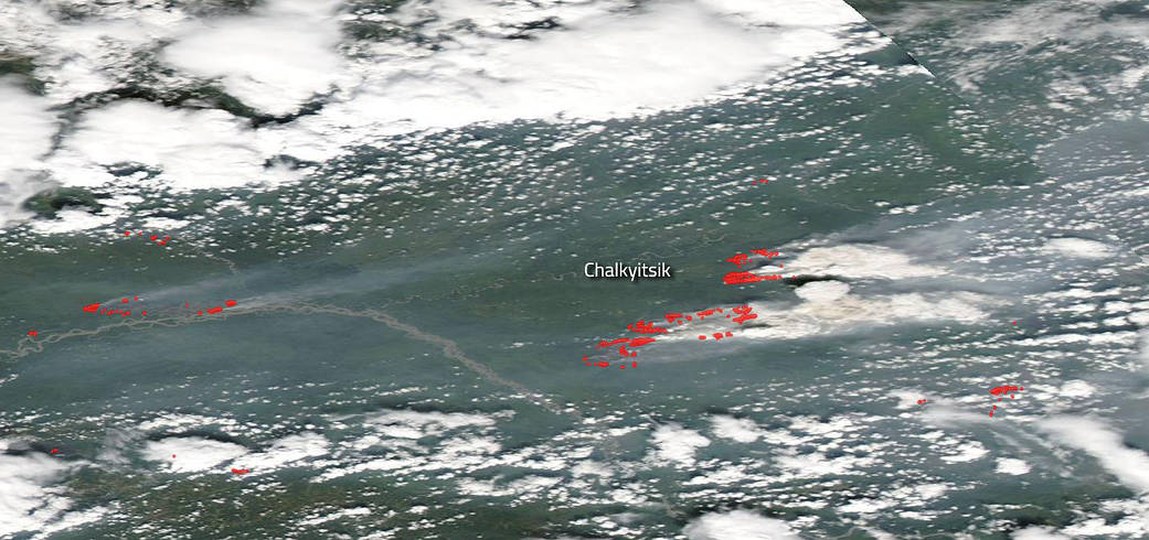
Alaska is still setting the pace in the U.S. with the most wildfires and the largest acreage burned this season to date. The majority of these blazes are caused by lightning strikes according to the Alaska Interagency Coordination Center as of July 15, 2019. But coming a very close second are fires caused by humans. The large difference though is in the acreage burned. Only 36,666 acres burned were human caused, whereas 1,602,301 acres burned were started by lightning strikes. The area of focus for this update is the Chalkyitsik area of Alaska, located 169 miles northeast of Fairbanks and 50 miles east of Fort Yukon, where 267,773 acres have been affected by the complex of uncontained fires raging in this area. The complex is made up of four distinct areas of fire: Tettjajik Creek, Bearnose Hill, Frozen Calf and Tractor Trail 2. All of the fire fronts in this complex were lightning based with start dates ranging from June 22 to July 2. The complex is located fifteen miles east of Chalkyitsik, AK. The fuel for the blazes is mostly timber. The fires are exhibiting active fire behavior with wind-driven runs, flanking and backing. Numerous structures are threatened.
NASA’s Earth Observing System Data and Information System (EOSDIS) Worldview application provides the capability to interactively browse over 700 global, full-resolution satellite imagery layers and then download the underlying data. Many of the available imagery layers are updated within three hours of observation, essentially showing the entire Earth as it looks “right now.” This natural-color satellite image was collected by the Moderate Resolution Imaging Spectroradiometer (MODIS) aboard the Aqua satellite was collected on July 14, 2019. Actively burning fires, detected by thermal bands, are shown as red points. Image Courtesy: NASA Worldview, Earth Observing System Data and Information System (EOSDIS). Caption: Lynn Jenner with information from the Alaska Interagency Coordination Center.