


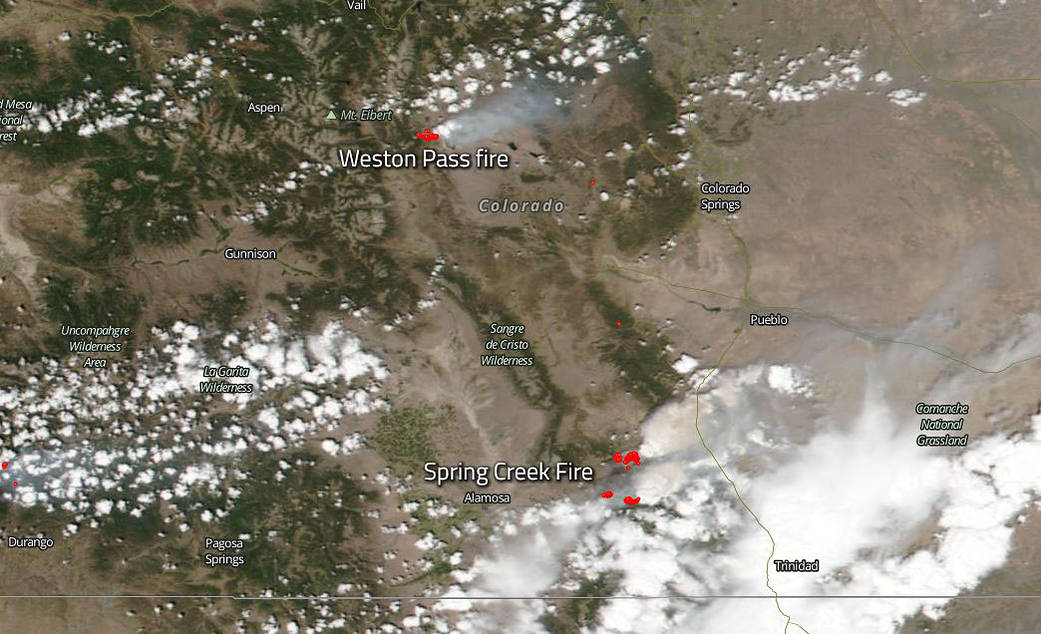
Both fires burning in Colorado, one west of Colorado Springs and one east of Alamosa began in late June and are continuing into July.
The Weston Pass fire is west of Colorado Springs and 9 miles southwest of Fairplay, Colorado. This fire began on June 28th with a lightning strike. At present the fire is 6,417 acres in size and is fueled by timber, brush, mixed conifer and stringers of aspen with grass/sage mix. Weather concerns are on high alert right now with higher temperatures, low relative humidity and winds that range fro 10-15 mph with gusts up to 25 mph. These type of weather conditions are conducive to fire growth. Fire personnel attacking this blaze number 313. This fire is 0% contained at present.
The Spring Creek Fire which is south of Colorado Springs and east of Alamosa began on June 27, 2018. This fire is located 9 miles NE of Ft. Garland, CO and is at 60,710 acres and is 5% contained. This fire was human caused. The fire continues to grow every day and moves quickly when it reaches a new area of dense fuel such as heavy, mixed conifer. Weather concerns are also an issue in this fire with continued hot, dry, unstable, and windy conditions experienced on Monday with wind gusts up to 37 mph and relative humidity of 7%. Isolated thunderstorm activity expected on Tuesday afternoon with scattered thunderstorms on Wednesday evening and Thursday. Thunderstorms bring lightning which is just another source of starting more fires. The amount of rain with these storms is usually negligible and the lightning strikes become the most worrisome factor in the weather event.
NASA’s Suomi NPP satellite collected this natural-color image using the VIIRS (Visible Infrared Imaging Radiometer Suite) instrument on July 02, 2018. Actively burning areas, detected by MODIS’s thermal bands, are outlined in red. Even with extensive cloud cover the smoke rising from these two fires can clearly be seen in this satellite image. NASA image courtesy NASA/Goddard Space Flight Center Earth Science Data and Information System (ESDIS) project. Caption by Lynn Jenner with information from Inciweb.
Suomi NPP is managed by NASA and NOAA.