


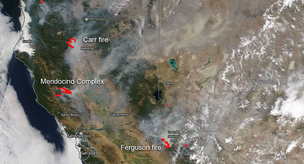
The Carr fire is now at 131,896 acres and is 39% contained at present. To date 1,067 residences, 19 commercial structures, and 481 outbuildings have been destroyed by this blaze. Still 1358 structures are potentially in the path of this powerful fire and are being threatened. Over 4300 personnel are battling the blaze and there are many mandatory evacuations in place. Crews worked through the night to quell potential spot fires across control lines. A Red Flag Warning was issued last night that will extend through Saturday.
The Mendocino Complex which consists of the Ridge and River fires is located directly south of the Carr fire near Ukiah and Clear Lake. The complex has seen 153,738 acres burned and is currently 30% contained. The unified command of the complex is by the CAL FIRE Mendocino Unit and the U.S. Forest Service. The River Fire is located northeast of the community of Hopland and northeast of Ukiah, in Lake County and Mendocino County, California. The Ranch Fire is actively burning in the Mendocino National Forest north of Clear Lake. The update for these fires as of today are as follows: “Both fires continue to remain active throughout the night. The Ranch fire made significant and rapid expansion to the east towards the Pawnee Fire scar. Today firefighters will continue to prep and defend structures along with construct primary and secondary control lines. Access and weather make many areas of the fire difficult to directly fight fire. ” This information is directly from Inciweb.
The Ferguson fire located southeast of the two other fires is right outside of Yosemite National Park. The total number of acres burned to date is 73,560 and is 41% contained. Now into its 22nd day, the Ferguson fire shows no signs of slowing down. Firefighters worked throughout the night to contain a couple of spot fires as they made progress toward full suppression of the Ferguson Fire. Weather concerns include a high pressure system above the fire that is weakening which will result in warmer and drier conditions. Lower wind speeds and the inversion layer forecasted to lift by midday will likely produce taller smoke columns above the fire.
For more on these fires go to the main Fire and Smoke page and search for each fire by name in the search box at the upper right hand corner of the page: https://www.nasa.gov/mission_pages/fires/main/index.html
This satellite image was captured on Aug. 02, 2018. Actively burning areas (hot spots), detected by thermal bands, are outlined in red. Each hot spot is an area where the thermal detectors recognized temperatures higher than background. When accompanied by plumes of smoke, as in this image, such hot spots are diagnostic for fire. NASA image courtesy of the NASA/Goddard Space Flight Center Earth Science Data and Information System (ESDIS) project. Caption by Lynn Jenner with information from Inciweb and CAL fire.