


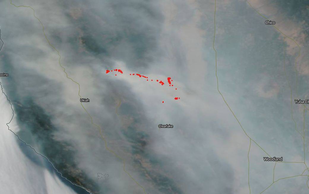
Details of the actual fire as well as the ground are obscured in NASA’s Aqua satellite image due to the heavy smoke coming off the Mendocino Complex fires as well as several other extremely large fires across California.
Today’s total of acreage consumed by the River and Range fires is 300,086 and the fires are 47% contained. The Mendocino Complex Fire doubled in size over the last few days and the Ranch and River Fires combined near Clear Lake to form the largest fire in California history. Weather concerns continue with a warm and dry ridge of high pressure continuing over the fire areas today. Fuel moisture recovery continues to be poor overnight. A red flag warning is predicted from Thursday through Saturday. This is the 13th day of this ongoing blaze. Over 4,000 firefighters have been involved in fighting this fire. There are still over 10,000 structures that are in danger. Yosemite National Park has been closed indefinitely due to the fire.
The smoke that hovers over the landscape is dangerous. In fact, the smoke released by any type of fire (forest, brush, crop, structure, tires, waste or wood burning) is a mixture of particles and chemicals produced by incomplete burning of carbon-containing materials. All smoke contains carbon monoxide, carbon dioxide and particulate matter (PM or soot). Smoke can contain many different chemicals, including aldehydes, acid gases, sulfur dioxide, nitrogen oxides, polycyclic aromatic hydrocarbons (PAHs), benzene, toluene, styrene, metals and dioxins. The type and amount of particles and chemicals in smoke varies depending on what is burning, how much oxygen is available, and the burn temperature.
Exposure to high levels of smoke should be avoided. Individuals are advised to limit their physical exertion if exposure to high levels of smoke cannot be avoided. Individuals with cardiovascular or respiratory conditions (e.g., asthma), fetuses, infants, young children, and the elderly may be more vulnerable to the health effects of smoke exposure. Residents should check AirNow at: https://www.airnow.gov/ for the current air quality index in their area.
NASA’s EOSDIS provides the capability to interactively browse over 600 global, full-resolution satellite imagery layers and then download the underlying data. Many of the available imagery layers are updated within three hours of observation, essentially showing the entire Earth as it looks “right now”. This natural-color satellite image was collected on July 18, 2018. Actively burning areas, detected by thermal bands, are outlined in red. NASA image courtesy NASA/Goddard Space Flight Center Earth Science Data and Information System (ESDIS) project. Caption: Lynn Jenner with information from Inciweb.