


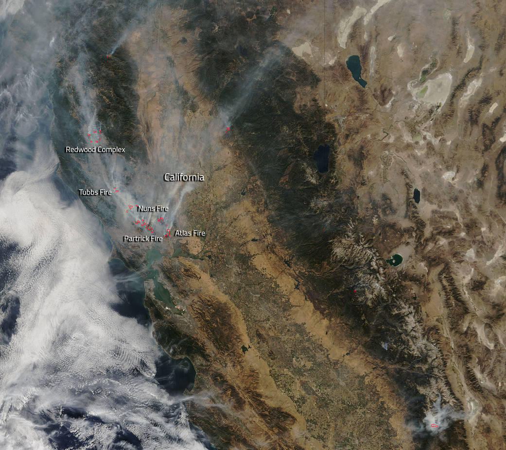
Wildfires continue to cause widespread destruction in the Sonoma Valley and Napa Valley areas of California. Hot, dry conditions, high winds, and lack of water in the area continue to hamper firefighter efforts in fighting these fires. Thousands of structures have been burned and stark landscapes show acres of standing fireplaces as the only structures that survived the fires that spread through neighborhoods. New evacuations have been called for as the fires continue to ravage this area of California.
The Southern LNU Complex of fires includes the Partrick Fire, the Atlas Fire and the Nuns Fire. The Partrick fire is located west of Napa, California and is 6,000 acres in size with only 1% of the fire contained. The cause of the Partrick fire is under investigation. The Nuns Fire is north of Glen Ellen and is 5,000 acres in size. This fire is also 1% contained at present. The Atlas Fire is 26,000 acres and is 3% contained. This fire is located off of Altas Peak Rd, south of Lake Berryessa in Napa County.

Five thousand structures are threatened by this complex of fires and dozens of evacuations have been instituted. All three fires experienced fire growth as a result of anticipated wind conditions. Forecasts include a change in wind speed and direction in the days to come. The forecast for Santa Rosa on Oct. 11 calls for sunshine and areas of smoke with northwest winds 8 to 14 mph, with gusts as high as 18 mph. Winds are expected to gust as high as 21 mph at night, and become light and variable on Thursday, Oct. 12. A Red Flag Warning continues to exist over the fire area.
The Tubbs fire is located near Calistoga and this fire is 28,000 acres in size. This fire is threatening over 16,000 structures with 571 structures already destroyed by the fire. The Central LNU Complex is comprised of the Tubbs Fire and the Pocket Fire. The California Fire website reports that: “Both fires continued to remain active. Firefighters are working in environments with downed powerlines, hazardous conditions and drought stricken trees. Increased onshore flow brought minor relief with slightly cooler weather, although we experienced an increase in fire activity due to light winds in the afternoon hours. Red Flag conditions are expected to continue through early Thursday morning.”
The Redwood Complex is comprised of the Redwood Fire and the Potter fire. This complex is located North of Hwy 20, west of Mendocino National Forest, south of Black Bart. Within the Redwood Complex 29,500 acres have burned and the complex is 5% contained. There have been 3 fatalities and approximately 7000 people evacuated throughout the incident. The cause of this fire is currently under investigation.
NASA’s Terra satellite collected this natural-color image with the Moderate Resolution Imaging Spectroradiometer, MODIS, instrument on October 10, 2017. Actively burning areas (hot spots), detected by MODIS’s thermal bands, are outlined in red. Each hot spot is an area where the thermal detectors on the MODIS instrument recognized temperatures higher than background. When accompanied by plumes of smoke, as in this image, such hot spots are diagnostic for fire. NASA image courtesy Jeff Schmaltz LANCE/EOSDIS MODIS Rapid Response Team, GSFC. Caption by Lynn Jenner with information from CA Fire website.