


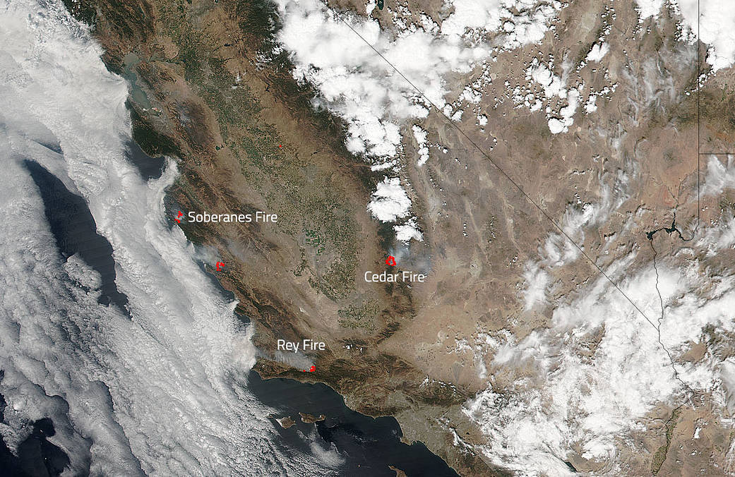
Southern California has been hard hit by wildfires this summer and the spate of fires continues in the rain comprised state. NASA and NOAA’s Suomi NPP satellite captured an image of the smoke rising from four different areas. Three of them are confirmed fires on the Inciweb site.
The Soberanes fire burning south of the Carmel Valley and northeast of Big Sur in Monterey County, California is 86,294 acre in size and 60% contained. Containment is now 60%. 2,109 personnel are currently assigned to this fire. The Soberanes fire has been burning since July 22, 2016. This fire was not started by a weather event, rather it was caused by an illegal, unattended campfire on the Soberanes Canyon trail in the Garrapata State Park.
The Rey Fire which started on August 18 at White Rock has grown to 21,172 acres and is currently 20% contained with 1,260 personnel on scene. Weather has not helped firefighters with a persistence of warm and dry conditions over the fire area that will continue through the weekend. The Rey Fire has continued to display extreme fire behavior due to dry vegetation burning in some areas with no recorded fire history, making for very combustible fuel.
The Cedar Fire, located North of Alta Sierra and west of Kernville, began on Tuesday, August 16, and the cause of the fire is still under investigation. It is currently 19, 629 acres in size with only 5% containment. Smoky conditions persisted through the night and will continue today until the inversion lifts. The afternoon might bring some clearing of the smoke. Over 1800 personnel are fighting this fire. Evacuations around the area are in place and can be found here: http://inciweb.nwcg.gov/incident/4964/
NASA’s Suomi NPP satellite collected this natural-color image using the VIIRS (Visible Infrared Imaging Radiometer Suite) instrument on August 21, 2016. Actively burning areas, detected by MODIS’s thermal bands, are outlined in red. NASA image courtesy Jeff Schmaltz LANCE/EOSDIS MODIS Rapid Response Team, GSFC. Caption by Lynn Jenner with information from Inciweb.
Suomi NPP is managed by NASA, NOAA and the U.S. Department of Defense.