


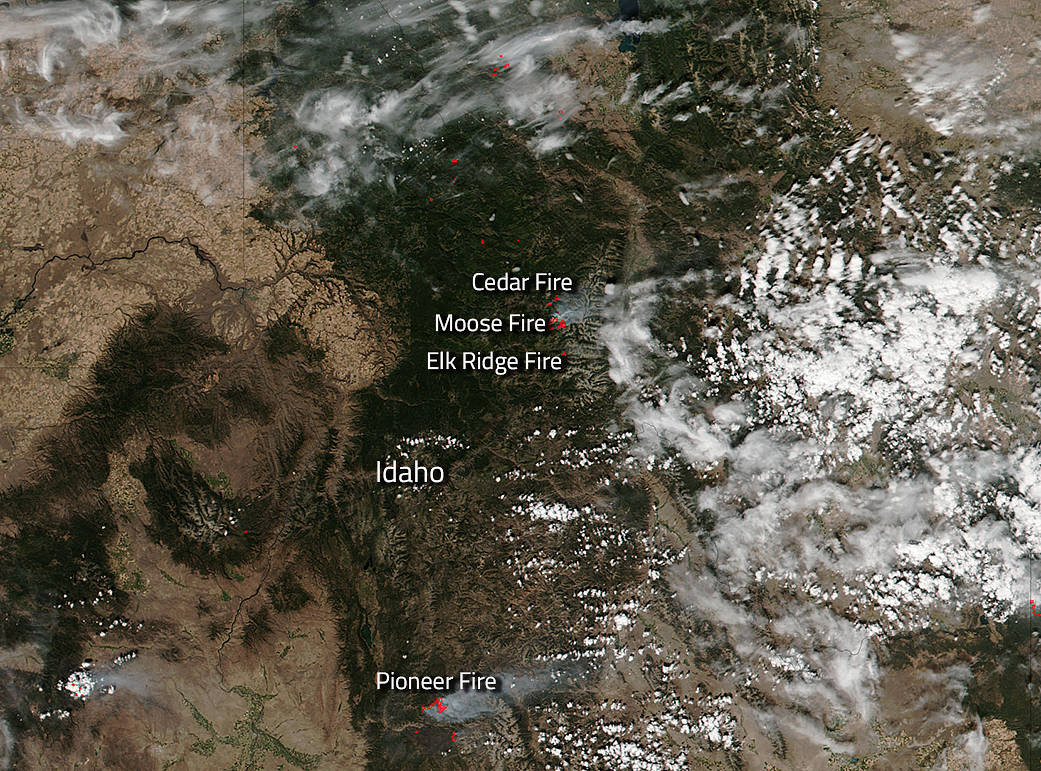
Fires in the state of Idaho continue to plague residents. This wildfire season has been extremely rough on the western states and Idaho is in the thick of it. This NASA Suomi NPP satellite image taken on August 28, 2016, by the VIIRS (Visible Infrared Imaging Radiometer Suite) instrument onboard shows a multitude of fires across the state. Three fires are all clustered around the Selway-Bitterroot Wilderness and the Pioneer Fire south of these fires continues to grow.
The Cedar Fire (northernmost of the trio of fires) which began as a lightning strike on July 17, 2016, continues to burn in the Selway-Bitterroot Wilderness and is under the management of the Powell Ranger Station. The fire is located 2 miles northwest of Elk Summit and 11 miles south of the Powell Ranger Station. It is currently 3,631 acres in size and the fire activity is has exhibited has been minimal except for recent spreading due to gusty winds. Cedar Fire will continue to be closely monitored by ground and aerial resources. The fire is currently not threatening life or property.
The Moose fire began as a lightning strike on August 15 (the middle of the trio of fires) and is producing copious amounts of smoke in the Selway-Bitterroot Wilderness. There was increased burning activity in the western and northern edges of the fire last Friday, August 26 as evidenced in a satellite map. The Moose fire is about eight miles from the Bitterroot National Forest, on the Nez Perce-Clearwater Forests and is being monitored by fire officials.
The Elk Ridge fire, the southernmost of the three fires, began on August 13 and is approximately 575 acres. It is located 15 miles east of the Moose Creek Ranger Station. The fire is burning in timber with minimal fire activity. The fire is remote with no threats to life or property and no potential values at risk are identified. The fire will continue to be managed for resource objectives and monitored daily.
The Pioneer Fire is located south of the trio of fires and is by far the largest of the fires noted in this update. The Pioneer Fire began on July 18, 2016 and the cause of the blaze is currently under investigation. At present this fire is 111,604 acres in size and is 55% contained. Almost 1400 personnel are battling this blaze. Fire activity in portions of the Deadwood Ridge and in Nellie’s Basin will likely increase over the next week as the temperatures rise and the relative humidity decreases. Temperatures are expected to reach the low 90’s as the dry and unstable air mass builds over the area of the fire. No significant moisture is expected this coming week. The fire is expected to move to the north and east, away from the Clear Creek and Long Creek roads.
Actively burning areas, detected by MODIS’s thermal bands, are outlined in red. NASA image courtesy Jeff Schmaltz LANCE/EOSDIS MODIS Rapid Response Team, GSFC. Caption by Lynn Jenner with information from Inciweb and from the Idaho wildfire website.
Suomi NPP is managed by NASA, NOAA and the U.S. Department of Defense.