


NASA Infrared Imagery Shows Tropical Depression Ivette Weakening
Tropical Depression Ivette continues to weaken in the Central Pacific Ocean and infrared data from NASA’s Aqua satellite showed a small area of strong storms remaining in the system.
The Atmospheric Infrared Sounder or AIRS instrument aboard NASA’s Aqua satellite looked at the weakening storms within Tropical Depression Ivette on Aug. 8 at 7:08 a.m. EDT (11:08 UTC). There was only one area with some strong storms remaining in the circulation and that was seen in the northeastern quadrant.
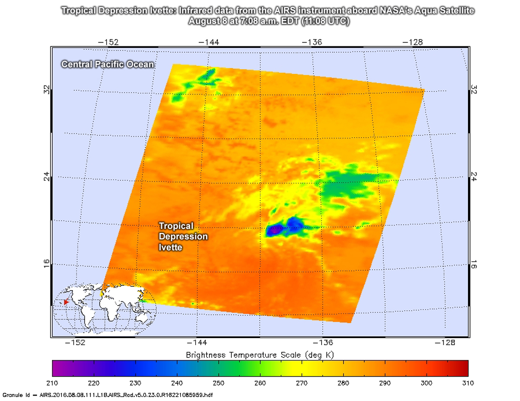
At 11 a.m. EDT (5 a.m. HST/1500 UTC), the center of Tropical Depression Ivette was located near 17.0 north latitude and 141.1 west longitude. That’s about 935 miles (1,505 km) east of Hilo, Hawaii and 1,135 miles (1,825 km) east-southeast of Honolulu, Hawaii.
The depression is moving toward the west near 8 mph (13 kph). A turn toward the west-southwest and a slight increase in forward speed is expected during the next day or two. Maximum sustained winds are near 35 mph (55 kph) with higher gusts.
NOAA’s Central Pacific Hurricane Center said, “Southwesterly vertical wind shear is taking its toll on Ivette, as the low-level circulation center of the depression has now been devoid of deep convection for over 12 hours.” That strong vertical wind shear is expected to continue for the next several days which will prevent thunderstorms from reforming around the center of circulation.
The CPHC forecast calls for additional weakening and Ivette is expected to become a remnant low later today.
Rob Gutro
NASA’s Goddard Space Flight Center, Greenbelt, Md.
Aug. 5, 2016 – NASA’s Terra Satellite Sees Tropical Storm Ivette Holding Steady
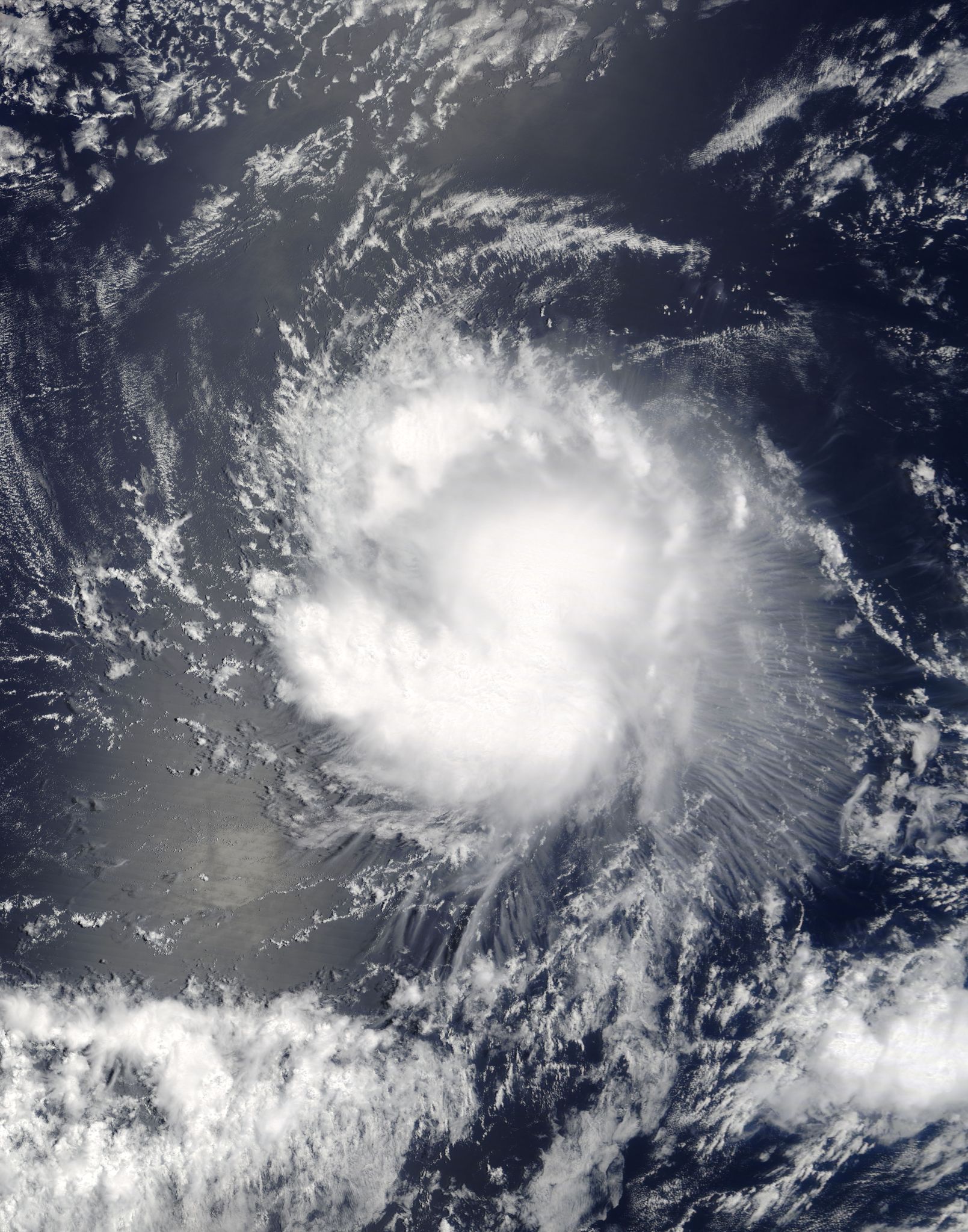
Bands of thunderstorms were wrapping around the center of Tropical Storm Ivette when NASA’s Terra satellite passed overhead.
On Aug. 4 at 3:20 p.m. EDT (1920 UTC), the Moderate Resolution Imaging Spectroradiometer aboard NASA’s Terra satellite captured a visible image of Tropical Storm Ivette. The image showed strong storms surrounded the low-level center of circulation and a thick band of powerful thunderstorms extended south of the center, while a fragmented band was north of the center.
At 5 a.m. EDT (0900 UTC) on Aug. 5 the center of Tropical Storm Ivette was located near 14.5 north latitude and 129.7 west longitude. Ivette is moving toward the west near 14 mph (22 kph). The National Hurricane Center (NHC) predicts a turn toward the west-northwest at a slightly slower forward speed by Saturday. Maximum sustained winds are near 50 mph (85 kph) with higher gusts. Some slight strengthening is possible during the next day or so.
The low-level center remains exposed to the west and northwest of a loosely curved band of thunderstorms, due to westerly to northwesterly shear.
NHC forecaster Daniel Brown noted, “Although the [vertical wind] shear is not very strong, it appears the small size of the cyclone and perhaps some nearby dry mid-level air in combination with the shear have prevented intensification during the past day.”
In two days, cooler waters and increased wind shear are expected to weaken Ivette. NHC forecasts Ivette to become a remnant low pressure area in four or five days.
For updates on Ivette, visit the NHC website at: www.nhc.noaa.gov.
By Rob Gutro
NASA’s Goddard Space Flight Center, Greenbelt, Md.
Aug. 4, 2016 – NASA Sees Wind Shear Affecting Compact Tropical Storm Ivette
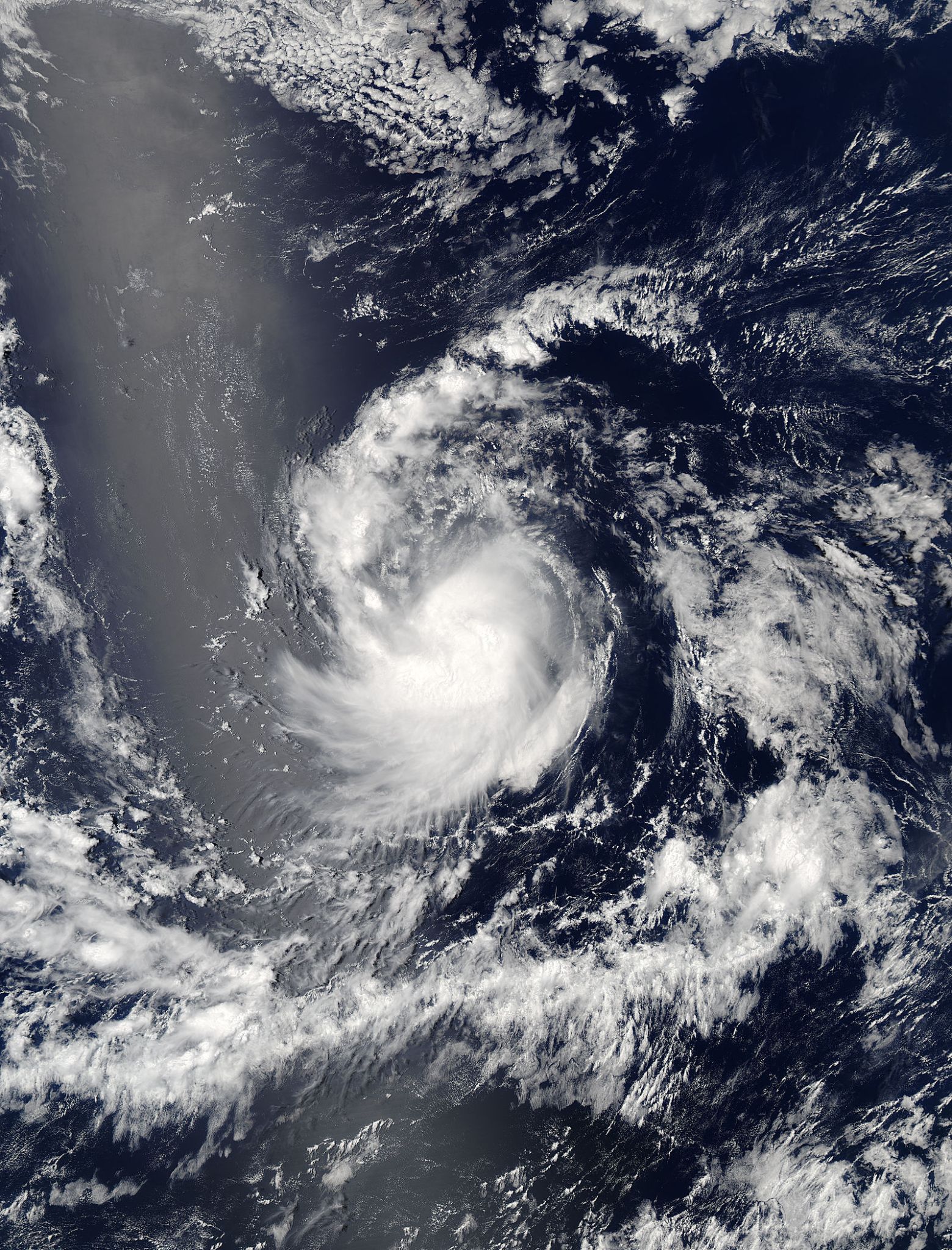
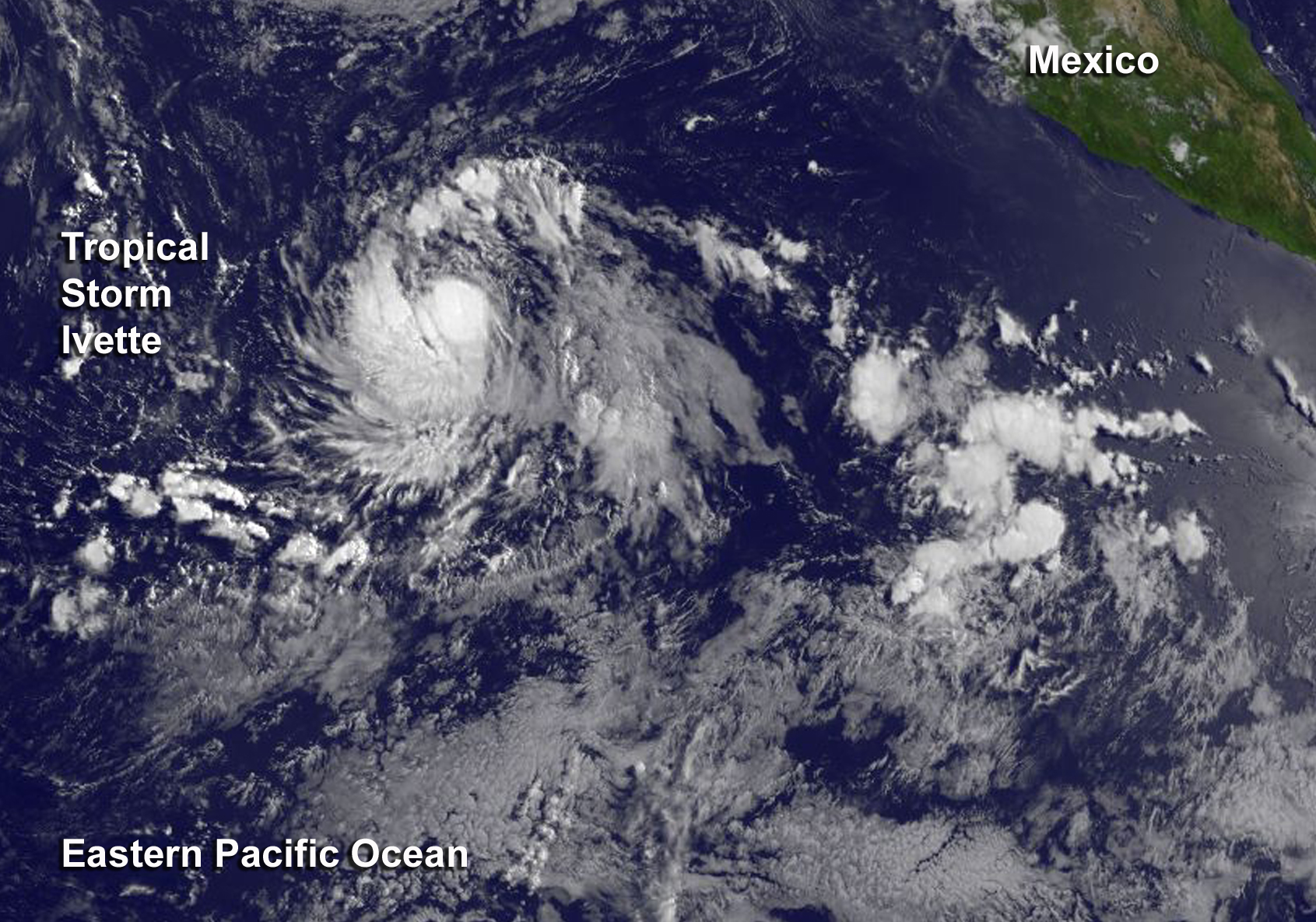
NASA’s Aqua satellite captured a visible light image of Tropical Storm Ivette fighting against wind shear in the Eastern Pacific Ocean.
NASA’s Aqua satellite passed over Ivette on August 3 at 5:45 p.m. EDT (21:45 UTC) and the Moderate Resolution Imaging Spectroradiometer instrument captured a visible light image of the storm. At the time the low-level center was located to the north-northeast of the deepest convection and thunderstorms as a result of moderate northeasterly vertical wind shear.
At 5 a.m. EDT (9:00 UTC) on August 4, National Hurricane Center forecaster Daniel Brown said “[Wind] shear and the entrainment of dry mid-level air appear to have taken a toll on Ivette, as the thunderstorm activity has decreased in coverage and organization during the past 12 hours or so.” Brown’s forecast discussion said, the current lack of organization and nearby dry air is likely to prevent significant intensification today. However, strengthening is still anticipated by tonight or Friday when Ivette is forecast to be over warm water and in a low shear environment.”
The center of Tropical Storm Ivette was located near 14.6 degrees north latitude and 124.7 degrees west longitude. That’s about 1,120 miles (1,800 km) west-southwest of the southern tip of Baja California, Mexico. Because it is so far from land, there are no coastal watches or warnings in effect.
Ivette is moving toward the west near 15 mph (24 kph), and this motion with some decrease in forward speed is expected over the next couple of days. The estimated minimum central pressure is 1004 millibars.
Maximum sustained winds are near 45 mph (75 kph) with higher gusts. Ivette is a compact storm as tropical-storm-force winds extend outward up to 80 miles (130 km) from the center.
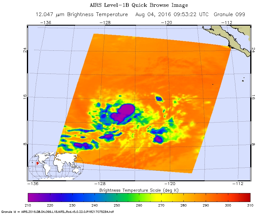
On August 4 at 5:53 a.m. EDT (9:53 UTC) the Atmospheric Infrared Sounder or AIRS instrument aboard Aqua looked at the storm in infrared light providing cloud top temperature data. The strongest storms within Ivette were still southwest of the center, indicating wind shear was still affecting the storm. Coldest cloud top temperatures in that part of the storm were as cold as minus 63 degrees Fahrenheit (minus 53 degrees Celsius).
The National Hurricane Center noted that some gradual strengthening is forecast during the next couple of days, and Ivette could become a hurricane late Friday or Friday night.
For updated forecasts, visit the NHC web page: www.nhc.noaa.gov.
By Rob Gutro
NASA’s Goddard Space Flight Center, Greenbelt, Md.
Aug. 3, 2016 – Satellite Spots New Tropical Storm Ivette Far from Baja California
Tropical Depression 10E formed on Aug. 2 around 5 p.m. EDT and strengthened into Tropical Storm Ivette 12 hours later at 5 a.m. EDT on Aug. 3. NOAA’s GOES-West satellite spotted Ivette almost 900 miles southwest of the southern tip of Baja California, Mexico on Aug. 3.
The visible image from NOAA’s GOES-West satellite from Aug. 3 at 11 a.m. EDT shows a concentrated ring of thunderstorms around the center of Tropical Storm Ivette and a band of thunderstorms west of the center.
National Hurricane Center (NHC) forecaster Berg said, “However, recent microwave data still shows the low-level center displaced to the northeast of the deepest convection due to some [vertical wind] shear.”
At 11 a.m. EDT (1500 UTC) the center of Tropical Storm Ivette was located near 14.6 degrees north latitude and 120.4 degrees west longitude. That’s about 895 miles (1,440 km) southwest of the southern tip of Baja California. Ivette is moving toward the west-northwest near 17 mph (28 kph). NHC forecasts a westward motion with a gradual decrease in forward speed during the next couple of days.
Maximum sustained winds have increased to near 45 mph (75 kph) with higher gusts. Additional strengthening is forecast during the next 48 hours, and Ivette is expected to become a hurricane by Thursday night.
For updated forecasts, visit NHC: www.nhc.noaa.gov.
By Rob Gutro
NASA’s Goddard Space Flight Center, Greenbelt, Md.