


Post-Tropical Cyclone Julia Mixing With Cold Front Along U.S. East Coast
The National Hurricane Center issued their final advisory on post-tropical cyclone Julia today, Monday, Sept. 19 at 0300 UTC (Sept. 19 at 11 p.m. EDT). At that time there were no coastal warnings or watches in effect. Julia’s remnants were interacting with a cold front and bringing much needed rainfall to parched New England and U.S. Mid-Atlantic states.
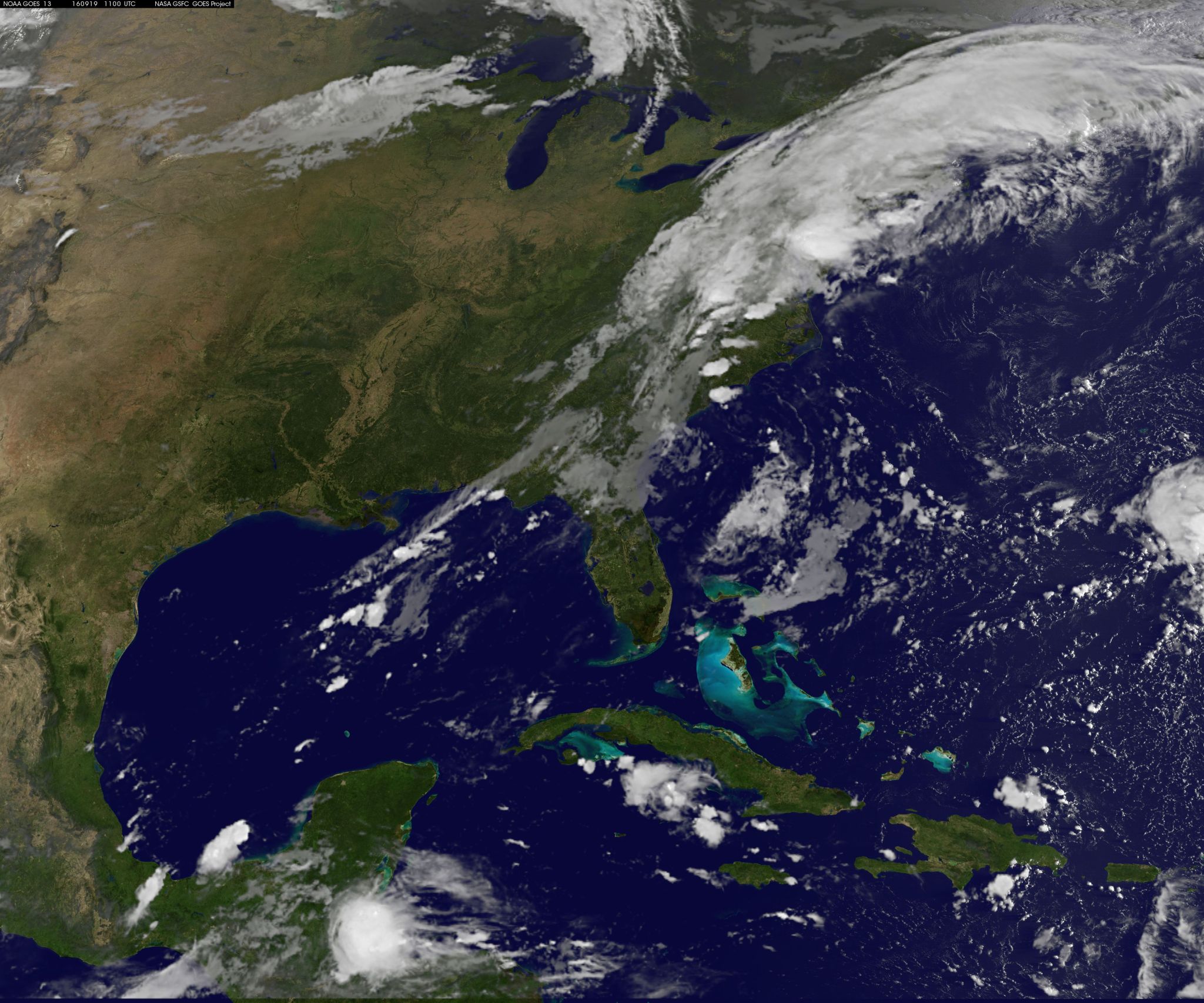
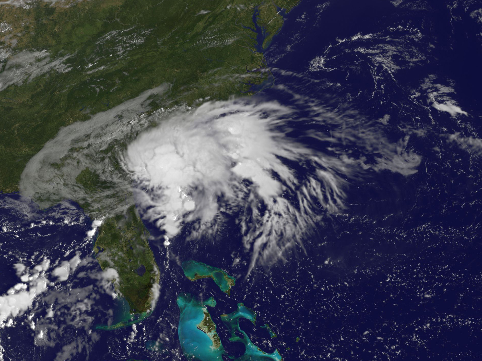
NOAA’s GOES-East satellite captured an infrared image of the clouds associated with the cold front and the remnants on Sept. 19 at 1100 UTC (7 a.m. EDT). the image showed a large swath of clouds from the Carolinas to Maine and into eastern Canada.
The image was created by the NASA/NOAA GOES Project at NASA’s Goddard Space Flight Center in Greenbelt, Maryland.
Post-Tropical Julia’s center was located near 32.2 degrees north latitude and 78.4 degrees west longitude. At that time, the center of Julia was about 110 miles (175 km) south-southeast of Myrtle Beach, South Carolina. Julia was moving to the northwest at 6 knots and maximum sustained winds were down to 25 knots.
The National Hurricane Center said “The interaction of the remnants of Julia with a weak cold front pushing slowly eastward across the Northeast and Mid-Atlantic states is expected to produce total rainfall amounts of 2 to 4 inches across eastern portions of the Mid-Atlantic region northward into eastern New York and southern New England through Tuesday, Sept. 20. Isolated maximum amounts of 8 inches will be possible, especially over portions of eastern North Carolina northward into parts of eastern Virginia, eastern Maryland, Delaware, and southern New Jersey. These amounts could result in localized flooding or flash flooding.”
Rob Gutro
NASA’s Goddard Space Flight Center
Sept. 16, 2016 – NASA’s GPM Observes Rainfall in Tropical Storm Julia
Tropical storm Julia was downgraded to a tropical depression on Thursday, Sept. 15 and continues to linger of the coast of the U.S. Southeast. The Global Precipitation Measurement mission (GPM) core satellite analyzed the rainfall within the storm.
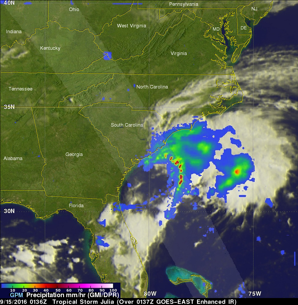
The GPM core observatory satellite had an excellent view of tropical storm Julia on Sept.14 at 9:36 p.m. EDT (Sept.15 0136 UTC). Julia was barely a tropical storm at that time with maximum sustained winds of about 40 mph (35 knots). Over the past few days Julia has dropped heavy rain along the Atlantic coastline from northeastern Florida to North Carolina. Some areas have received over 8 inches (203 inches) during the past few days.
The GPM satellite measured Julia’s rainfall and found that intense storms in an off shore rain band was producing very heavy downpours. GPM’s Dual-Frequency Precipitation Radar (DPR) saw rain falling at a rate of over 9 inches (229 mm) per hour in some storms.
Credits: NASA/JAXA, Hal Pierce
The GPM satellite made 3-D measurements of precipitation within Julia and discovered that some storm tops in this and band of heavy showers were reaching heights greater than 9.3 miles (15 km). GPM is a joint mission between NASA and the Japan Aerospace Exploration Agency JAXA.
At 5:00 AM EDT on Sept. 16, Tropical Storm Julia was located off the shore of South Carolina and is moving toward the southeast near 5 mph (7 km/h). Julia is expected to exhibit a slow and erratic motion offshore during the next couple of days. Maximum sustained winds are near 40 mph (65 km/h) with higher gusts. Little change in strength is forecast today, but gradual weakening is anticipated after that time. Tropical-storm-force winds extend outward up to 70 miles (110 km) from the center.
Hal Pierce/Rob Gutro
NASA’s Goddard Space Flight Center
Sept. 15, 2016 – NASA Sees Tropical Depression Julia Lingering in U.S. Southeast
NASA’s Terra satellite observed Tropical Storm Julia in the U.S. Southeast on Sept. 14 and the storm continued to linger there. The National Hurricane Center said that expected to meander off the coast of Georgia and South Carolina for the next few days.
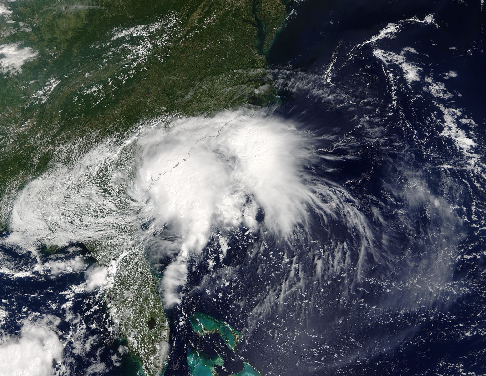
On Sept. 14 at 11:55 a.m. EDT (15:55 UTC) the Moderate Resolution Imaging Spectroradiometer or MODIS instrument that flies aboard NASA’s Terra satellite captured a visible image of Julia. At the time of the image, Julia was still a tropical storm with maximum sustained winds near 40 mph (65 kph) and the center of Julia was located about 20 miles (30 km) northeast of Brunswick, Georgia. The image showed that westerly vertical wind shear was affecting the storm, pushing clouds and showers east of the center of circulation and over the Atlantic Ocean.
By 5 a.m. EDT (0900 UTC) on Sept. 15, Julia had weakened to a depression. At 11 a.m. EDT (1500 UTC) the center of Tropical Depression Julia was located near 31.8 degrees north latitude and 78.2 degrees west longitude. Julia was centered about 125 miles (200 km) east-southeast of Charleston, South Carolina, and about 165 miles (270 km) south of Wilmington, North Carolina.
The depression is moving toward the east near 8 mph (13 kph). The National Hurricane Center (NHC) expects decrease in forward speed followed by a slow and erratic motion offshore of the coasts of Georgia and South Carolina tonight through Saturday, Sept. 17. Maximum sustained winds are near 35 mph (55 kph) with higher gusts. The estimated minimum central pressure is 1010 millibars.
Little change in strength is forecast during the next 48 hours as Julia encounters unfavorable upper-level winds.
NHC said that Julia is expected to produce additional rainfall amounts of less than an inch across coastal sections of northeastern South Carolina and southeast North Carolina through Monday, Sept. 19.
For updated forecasts from NHC, visit: www.nhc.noaa.gov.
Rob Gutro
NASA’s Goddard Space Flight Center
Sept. 14, 2016 – Satellite Movie Shows Tropical Storm Julia Develop over Southeastern U.S.
Two days of infrared and visible imagery from NOAA’s GOES-East satellite were made into a movie that showed the development of Tropical Storm Julia over Florida and movement over southern Georgia by the morning of Sept. 14.
Credits: NASA/NOAA GOES Project
System 94L had been lingering around the Bahamas for a couple of days and moved over northeastern Florida on Sept. 13. On Sept. 13 at 2:25 p.m. EDT (18:25 UTC) the Moderate Resolution Imaging Spectroradiometer aboard NASA’s Aqua satellite took a visible image of developing System 94L over Florida. The image showed strong thunderstorms developing around the center of circulation and thunderstorms in a fragmented band to the north of the center.
By 11 p.m. EDT, the National Hurricane Center noted that the low pressure area quickly developed into a tropical storm. At that time it was centered just 5 miles (10 km) west of Jacksonville, Florida.
Overnight from Sept. 13 to the early morning of Sept. 14 there was a Tropical Tropical Storm Warning from Fernandina Beach to Altamaha Sound, but as of 8 a.m. EDT on Sept. 14, that warning has been discontinued.
At NASA’s Goddard Space Flight Center in Greenbelt, Maryland, the NASA/NOAA GOES Project created an animation using of NOAA’s GOES-East satellite imagery from Sept. 12 to Sept. 14 that shows the development of Tropical Storm Julia over Florida and movement into Georgia. NOAA operates and manages the GOES series of satellites and NASA/NOAA’s GOES Project creates images and animations from the data.
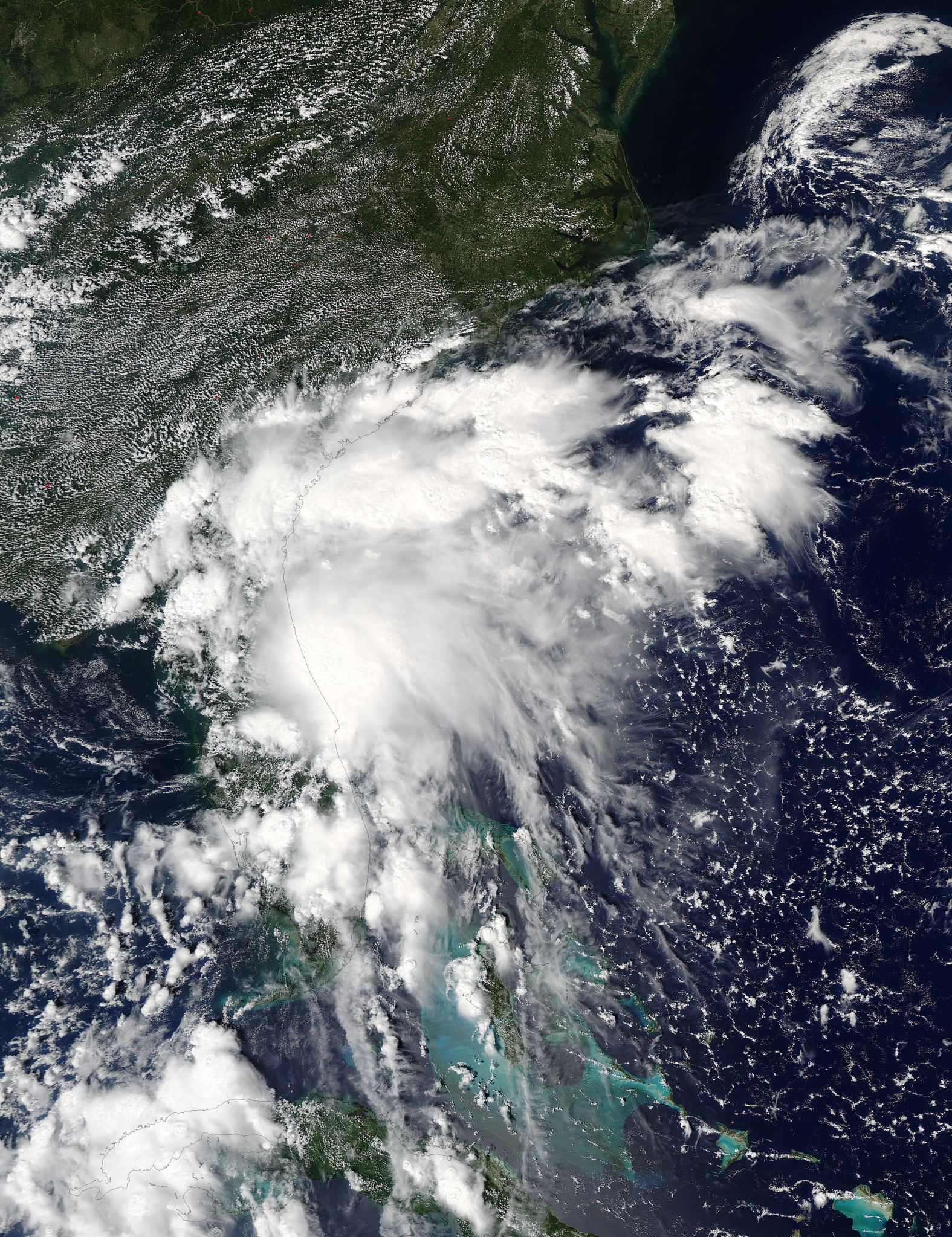
At 8 a.m. EDT (1200 UTC) on Sept. 14 the center of Tropical Storm Julia was located near 31.2 degrees north latitude and 81.7 degrees west longitude. That’s about 10 miles (20 km) west of Brunswick, Georgia. Julia is moving toward the north near 7 mph (11 kph). A reduction in forward speed is expected today, and Julia is forecast to drift northward over eastern Georgia during the next couple of days.
Maximum sustained winds are near 40 mph (65 kph) with higher gusts. Tropical-storm-force winds extend outward up to 80 miles (130 km) primarily over water to the northeast of the center.
The National Hurricane Center (NHC) said “Julia is expected to produce 3 to 6 inches of rain near the Georgia and South Carolina coastlines through Friday afternoon. Isolated totals of 10 inches are possible. This rainfall could lead to flash flooding. Flooding may be further compounded with persistent strong onshore flow reducing river and stream discharges. Additional rainfall amounts of 1 to 2 inches are possible across northeast Florida today. An isolated tornado is possible across coastal Georgia and southern South Carolina today, Sept. 14.”
Gradual weakening is forecast during the next day or so, and Julia is expected to weaken to a tropical depression later on Sept. 14.
For updates on Julia, visit the NHC website: www.nhc.noaa.gov.