


NASA/NOAA GOES Satellite Sees Post-Tropical Ian Rocketing Towards the Northeast
Post-tropical Cyclone Ian is moving very rapidly to the northeast and will be absorbed by a frontal system tomorrow. The post-tropical cyclone is moving toward the northeast near 53 mph (85 km/h), and this motion is expected to continue through tonight, with a decrease in forward speed expected on Saturday.
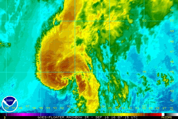
NOAA’s GOES-East satellite captured this series of images which was made into an animated GIF showing the swirling winds of Post-tropical cyclone Ian as it rocketed eastward away from any land masses.
Maximum sustained winds are near 65 mph (100 km/h) with higher gusts. The post-tropical cyclone should gradually weaken over the next 36 hours before becoming absorbed by an extratropical low. Tropical-storm-force winds extend outward up to 240 miles (390 km) from the center. There are no coastal watches or warnings in effect.
There are no plans at the National Hurricane Center for further updates on Ian.
Lynn Jenner
NASA’s Goddard Space Flight Center
Sept. 15, 2016 -NASA’s Terra Satellite Spots Tropical Storm Ian Speeding Through Central Atlantic
Tropical Storm Ian is speeding in a northeasterly direction through the North Central Atlantic Ocean as it transitions to a post-tropical storm. NASA’s Terra satellite captured a visible image of the storm.
On Sept. 14 at 10:15 a.m. EDT (14:15 UTC) the Moderate Resolution Imaging Spectroradiometer or MODIS instrument that flies aboard NASA’s Terra satellite captured a visible image of Tropical Storm Ian when it was about 700 miles east of Bermuda. At the time of the image, National Hurricane Center (NHC) forecaster Berg noted that satellite imagery showed “Ian’s center has lost some definition and appears to have re-formed north of the feature we had been tracking. The center remains exposed to the south and southeast of the deep convection due to almost 30 knots of vertical shear.”
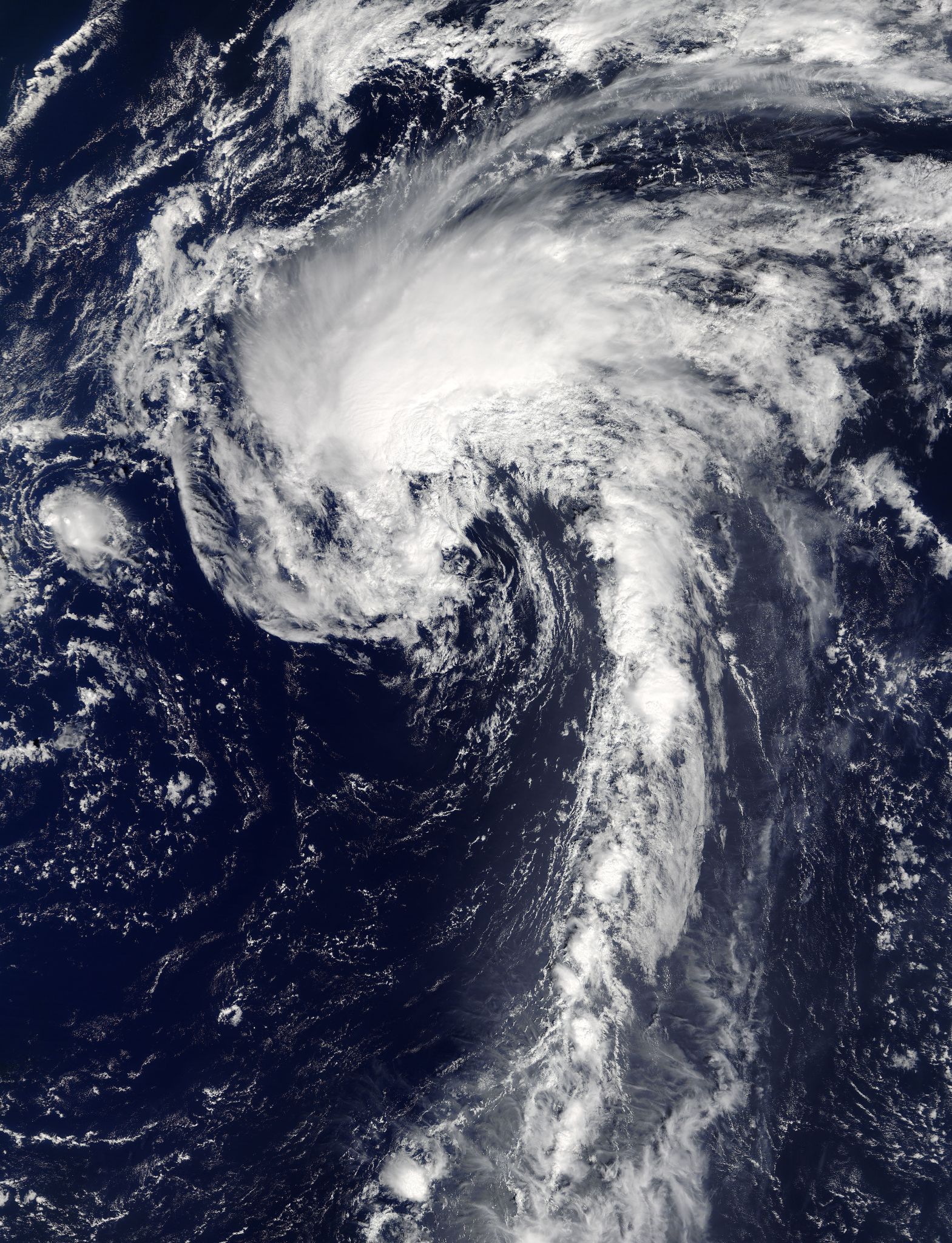
On Sept. 15, a mid-latitude trough, or elongated area of low pressure has picked up Tropical Storm Ian and is accelerating it to the northeast.
At 11 a.m. EDT (1500 UTC), the center of Tropical Storm Ian was located near 37.2 degrees north latitude and 50.5 degrees west longitude. That’s about 880 miles (1,415 km) east-northeast of Bermuda and 1,285 miles (2,065 km) west of the Azores Islands.
Ian is moving toward the northeast near 24 mph (39 kph) and this motion is expected to continue with an increase in forward speed during the next 24 to 36 hours. Maximum sustained winds are near 50 mph (85 kph) with higher gusts.
NHC said that strengthening is forecast during the next 36 hours, and Ian is expected to become a storm-force extratropical low on Friday.
For updates on Ian, visit the NHC website at: www.nhc.noaa.gov.
Rob Gutro
NASA’s Goddard Space Flight Center
Sept. 14, 2016 – NASA Sees a Fan-Shaped Tropical Storm Ian in Central Atlantic Ocean
Tropical Storm Ian resembled a fan in NASA satellite imagery as a result of strong wind shear affecting the storm.
On Sept. 13 at 12:45 p.m. EDT (1645 UTC) the Moderate Resolution Imaging Spectroradiometer aboard NASA’s Aqua satellite captured this visible image of Tropical Storm Ian in the Central Atlantic Ocean. The image showed an elongated storm being affected by southerly vertical wind shear that was pushing clouds to the north of the storm’s center.
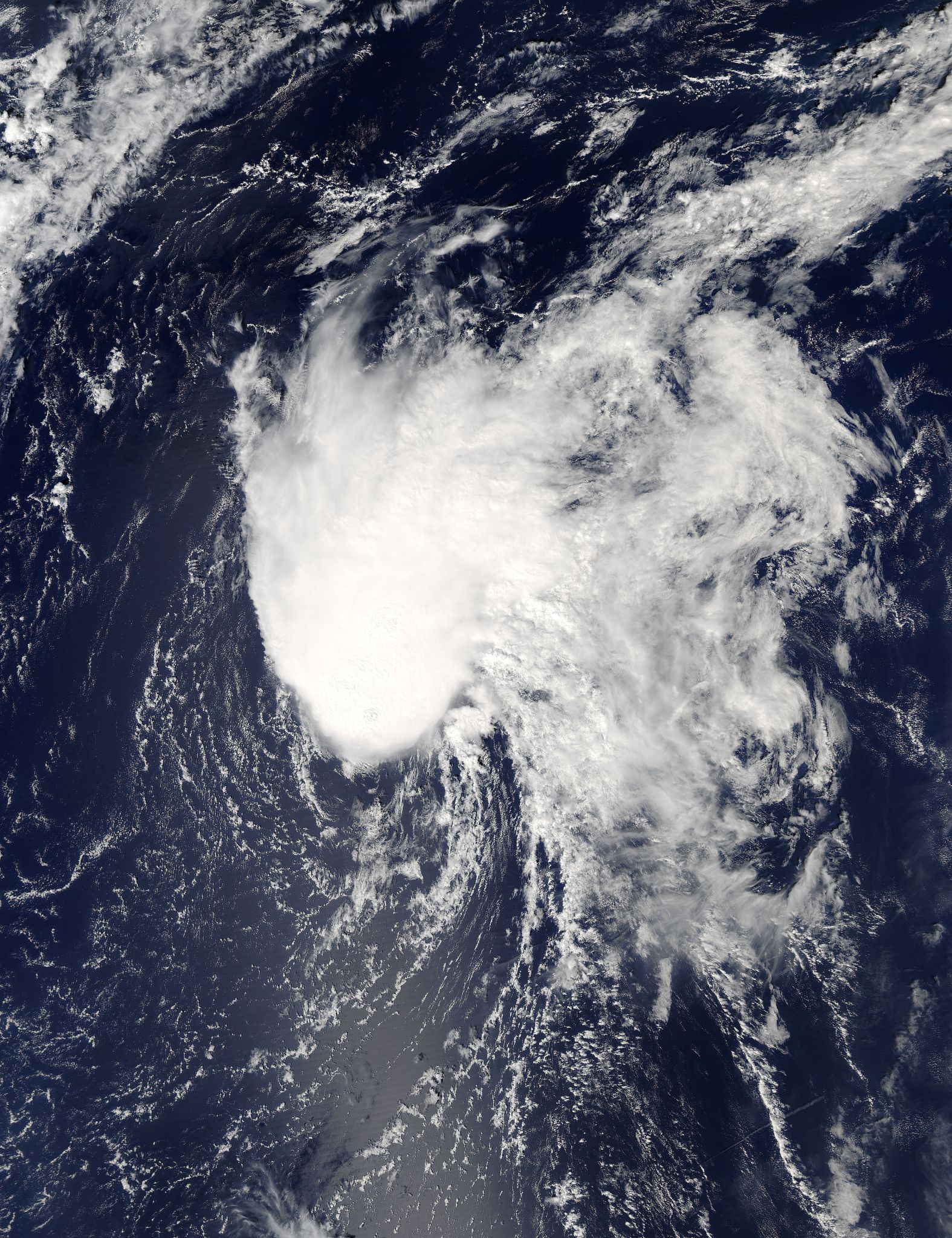
At the time of the image, the National Hurricane Center (NHC) said “The low-level center remains exposed to the south of a fan-shaped mass of deep convection. This structure is consistent with a deep-layer southwesterly vertical shear of nearly 40 knots associated with a mid- to upper-tropospheric cyclone to the west of the cyclone.
At 11 a.m. EDT (1500 UTC) on Sept. 14 the center of Tropical Storm Ian was located near 31.4 degrees north latitude and 53.0 degrees west longitude. That’s about 695 miles (1,120 km) east of Bermuda. Ian is moving toward the north near 20 mph (31 kph). The National Hurricane Center (NHC) said a northward motion at a slower forward speed is expected today and tonight, Sept. 14. A turn toward the north-northeast and northeast with an increase in forward speed is expected on Thursday, Sept. 15.
Maximum sustained winds are near 50 mph (85 kph) with higher gusts. Some strengthening is forecast during the next day or so, and Ian is expected to lose its tropical characteristics on Friday.
For updated forecasts, visit: www.nhc.noaa.gov.
Rob Gutro
NASA’s Goddard Space Flight Center
Sep. 13, 2016 – NASA Sees Formation of Central Atlantic Tropical Storm Ian
The low pressure area known as System 94L developed into Tropical Storm Ian on Sept. 14. NOAA’s GOES-East satellite data was made into an animation that showed the development of the central Atlantic storm.
Credits: NASA/NOAA GOES Project
An animation of GOES-East satellite visible and infrared imagery from Sept. 10 to 14 showed the development of Tropical Storm Ian in the Central Atlantic Ocean. The animation was created at the NASA/NOAA GOES Project at NASA’s Goddard Space Flight Center in Greenbelt, Maryland. The animation showed on Sept. 14 that Ian remains a sheared tropical storm, with the low-cloud center exposed to the south of the main area of deep convection and developing strong thunderstorms.
The National Hurricane Center noted that the strong vertical shear over Ian is being produced by an upper-level low pressure area located a couple of hundred miles to the west-northwest.
At 11 a.m. EDT (1500 UTC) on Sept. 13 the center of Tropical Storm Ian was located near 25.4 degrees north latitude and 52.3 degrees west longitude. That’s about 895 miles (1,435 km) east-southeast of Bermuda.
Maximum sustained winds are near 45 mph (75 kph) with higher gusts. Some slight strengthening is possible during the next couple of days. The estimated minimum central pressure is 1005 millibars.
The NHC said that Ian is moving toward the north-northwest near 13 mph (20 kph), and a turn toward the north and north-northeast at increasing forward speed is expected over the next 48 hours, remaining over the open waters of the Atlantic and no threat to land.
For updates on Ian, visit NOAA’s NHC website: www.nhc.noaa.gov.