


NASA Takes Parting Look at Hermine
Satellite imagery showed that Post-Tropical Cyclone Hermine was just a swirl of clouds with no rainfall off the coast of southeastern Massachusetts on Thursday, Sept. 8. Just two days earlier, the GPM satellite saw that Hermine was still generating some rainfall.
Credits: NASA/JAXA, Hal Pierce
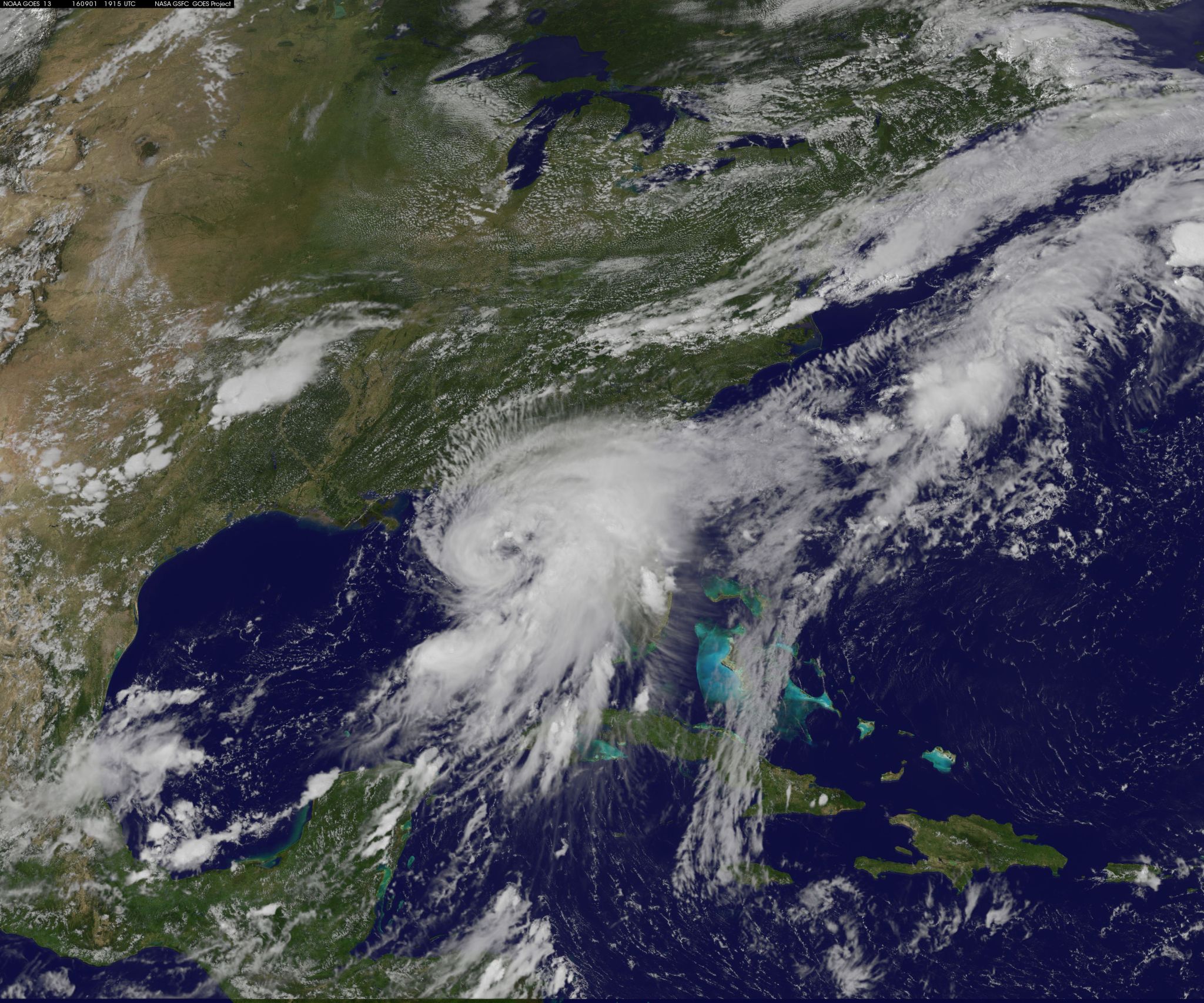
Post Tropical Cyclone Hermine was still rotating in the Atlantic Ocean east of New Jersey when the Global Precipitation Measurement mission or GPM core observatory satellite flew above on Sept. 6 at 2:05 p.m. EDT (1806 UTC). Hermine’s power was greatly dissipated from the hurricane that hit Florida on Sept. 2, 2016. Hermine still had maximum sustained winds of about 58 mph (50 knots). Hermine was also still producing some light to moderate showers.
Precipitation data derived from GPM’s Microwave Imager (GMI) and Dual-Frequency Precipitation Radar (DPR) instruments showed that rain was falling at a rate of over 1.1 inches (27 mm) per hour in an area of showers located between the Atlantic coast and Hermine’s center of circulation. GPM’s GMI also showed that moderate rainfall was still occurring in a few bands of rainfall south and southeast of the storm.
GPM’s radar (DPR Ku Band) made a 3-D slice through Hermine that showed the structure of precipitation within the storm. This 3-D scan showed that the tops of the storms on Hermine’s eastern side were reaching to altitudes of about 5.3 miles (8.5 km). GPM is a joint mission between NASA and the Japan Aerospace Exploration Agency JAXA.
The National Hurricane Center (NHC) discontinued coastal tropical storm warnings and terminated National Hurricane Center advisories on weakening Post-Tropical Cyclone Hermine on Sept. 6 at 2 p.m. EDT (1800 UTC).
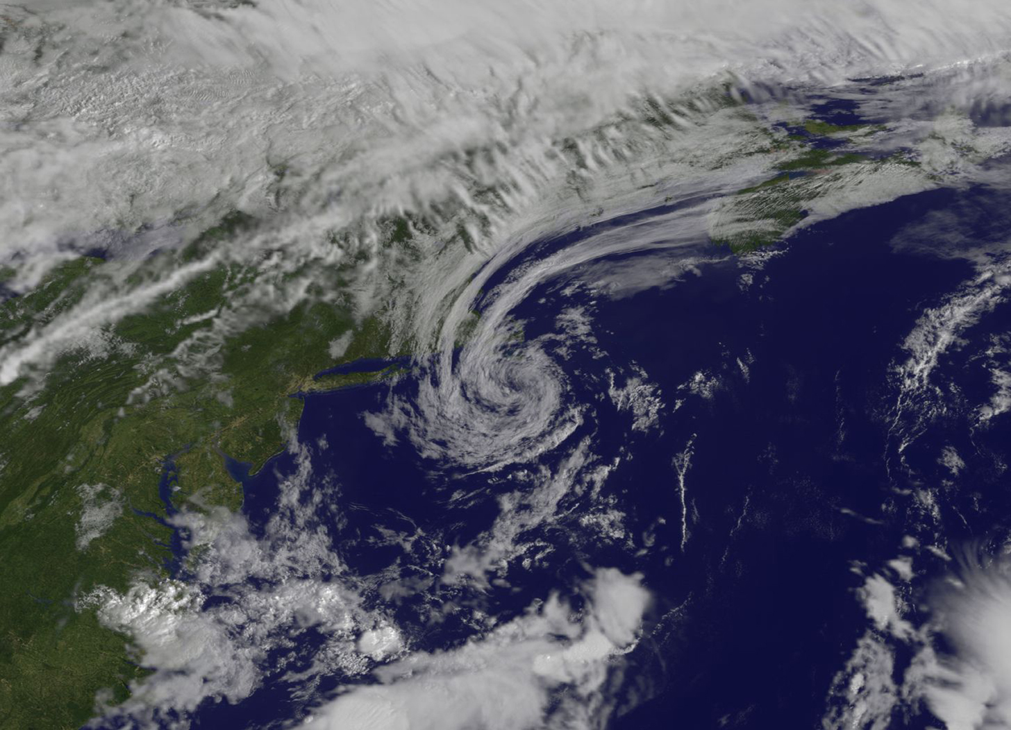
Visible imagery from NOAA’s GOES-East satellite on Sept. 8 at 9:30 a.m. EDT (1330 UTC) revealed the remnants of Hermine as a swirl of clouds located off of Cape Cod, Massachusetts. A line of clouds over northern New England from an oncoming cold front were located to the northwest of the remnants. The image was created at NASA’s Goddard Space Flight Center in Greenbelt, Maryland.
Once the cold front moves through it will absorb the remnant clouds of Hermine, and the storm will go down in hurricane history.
Harold Pierce / Rob Gutro
NASA’s Goddard Space Flight Center
Sept. 07, 2016 – NASA Sees Post-Tropical Storm Hermine South of Long Island, Last Advisory Issued
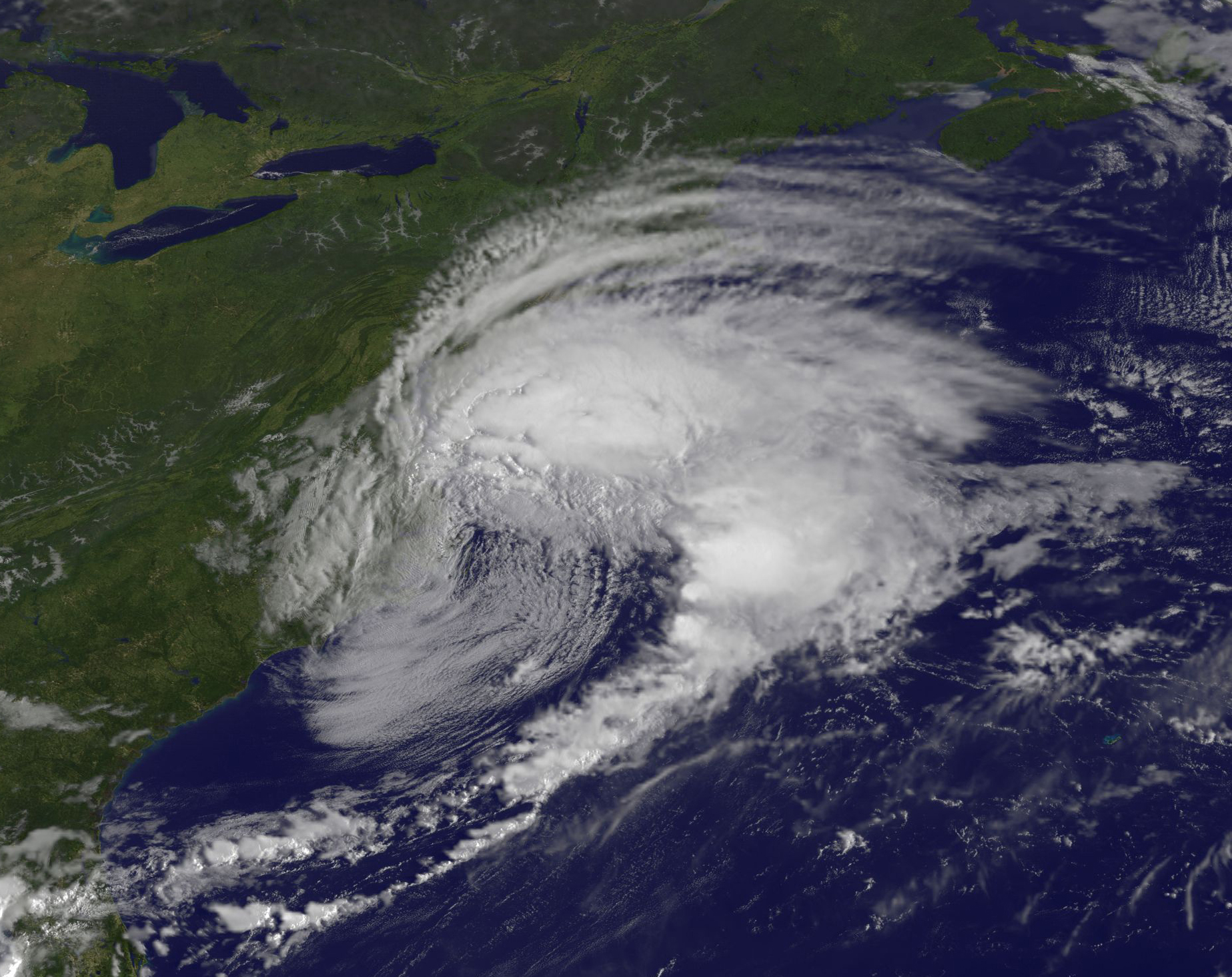
NOAA’s National Hurricane Center (NHC) issued their final warning on Post-Tropical Cyclone Hermine yesterday, Sept. 6 at 2 p.m. EDT. NASA’s Aqua satellite captured an image of the storm at that time and showed clouds stretching from New Jersey to Maine.
At the time of the NHC’s last advisory, Hermine’s center was about 120 miles south of the eastern tip of Long Island, New York, near 39.4 degrees north latitude and 72.3 degrees west longitude. Maximum sustained winds have decreased to near 50 mph (85 kph) with higher gusts. Additional gradual weakening is likely during the next couple of days, and Hermine may weaken below tropical storm force by Thursday, Sept. 8.
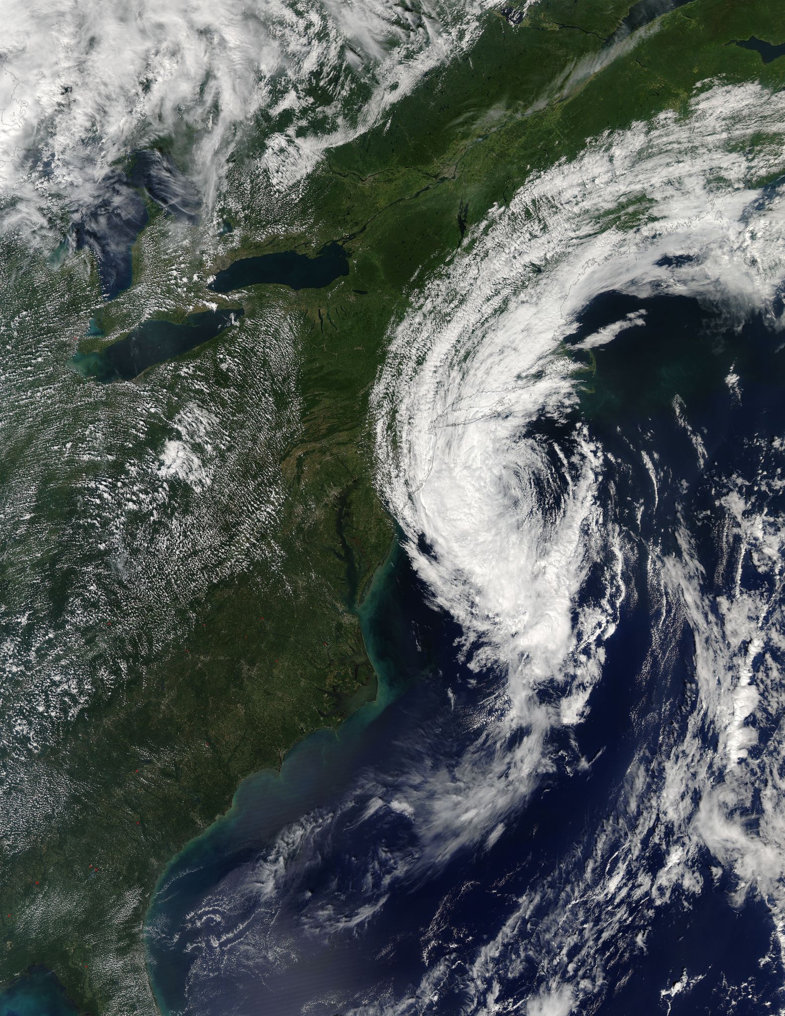
On Sept. 6 at 2:20 p.m. EDT (18:20 UTC), the Moderate Resolution Imaging Spectroradiometer or MODIS instrument aboard NASA’s Aqua satellite captured a visible image of Post-Tropical Storm Hermine. A thick band of strong thunderstorms covered the western side of the storm and extended from the Atlantic Ocean over Long Island. Bands of clouds stretched from New Jersey to Maine.
On Sept. 6, the NHC said Hermine was no longer a threat to land. Water levels remain elevated along the coast of Long Island, but they should subside during the next day or so as Hermine exits the area.

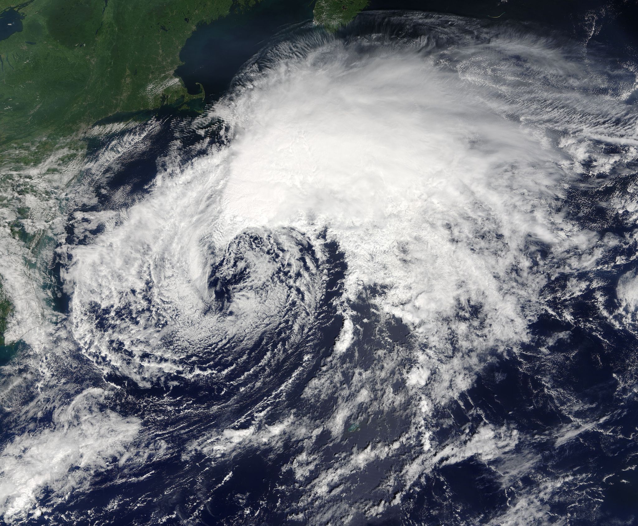
On Wednesday, Sept. 7 at 8:30 a.m. EDT (1230 UTC) NOAA’s GOES-East satellite captured a visible image of the clouds associated with Hermine still spinning south of Long Island. Compared to the imagery from NASA’s Aqua satellite the previous day, the clouds had thinned and there was only a line of thunderstorms around the western quadrant, while lower clouds surrounded the rest of the low pressure area. The image was created by NASA/NOAA’s GOES Project at the NASA Goddard Space Flight Center in Greenbelt, Maryland.
The center of Post-Tropical Cyclone Hermine is expected to be over 150 miles east-southeast of Cape Cod, Massachusetts, by 2 a.m. EDT on Thursday, Sept. 8 as it continues to moving in a northeasterly direction into the open waters of the North Atlantic Ocean.
Large waves generated by Hermine will continue to affect the U.S. east coast from the Mid-Atlantic States through New England for another couple of days. These waves are likely to cause life-threatening surf and rip current conditions, and significant beach erosion.
Rob Gutro
NASA’s Goddard Space Flight Center
Sept. 06, 2016 – NASA Sees Post-Tropical Cyclone Hermine Linger Over Northeastern U.S.
NASA and NOAA satellites continue to provide data as Post-Tropical Cyclone Hermine continues to linger south of Long Island, New York. The winds from the storm continue to affect surf from the Mid-Atlantic to Cape Cod, Massachusetts.

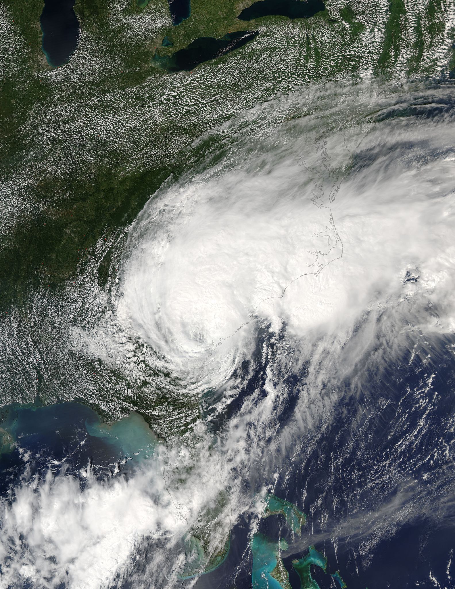
At 1:55 p.m. EDT (17:55 UTC) on Sept. 5, NASA-NOAA’s Suomi NPP satellite passed over Hermine and the Visible Infrared Imaging Radiometer Suite (VIIRS) instrument aboard NASA-NOAA’s Suomi NPP satellite captured a visible image of the storm lingering off the coast of New York and southern New England. The VIIRS image showed the bulk of clouds in the northwestern and northern quadrants where the strongest winds were located.
An animation of satellite imagery showing the slow movement of Hermine over two days was created by the NASA/NOAA GOES Project at NASA’s Goddard Space Flight Center in Greenbelt, Maryland. The animation of infrared and visible images from NOAA’s GOES-East satellite shows very little movement from Sept. 4 through Sept. 6 at 10 a.m. EDT (1400 UTC).
On Sept. 6 at 11 a.m. EDT NOAA’s National Hurricane Center (NHC) said A Tropical Storm Warning is in effect for the coast of Long Island from Fire Island Inlet to Port Jefferson Harbor. The tropical storm warning has been discontinued for Block Island, Rhode Island; Martha’s Vineyard and Nantucket, and the coast from New Haven, Connecticut to Sagamore Beach, Massachusetts.
At 11 a.m. EDT (1500 UTC), the center of Post-Tropical Cyclone Hermine was located near 39.5 degrees north latitude and 71.9 degrees west longitude. That puts the center of circulation just 110 miles (180 km) south of the eastern tip of Long Island, New York.
Credits: NASA/NOAA GOES Project
The post-tropical cyclone is moving toward the west near 3 mph (6 kph). NHC said a slow and erratic motion is expected for the rest of today and tonight, followed by a slow motion toward the northeast on Wednesday, Sept. 7. Maximum sustained winds have decreased to near 60 mph (95 kph) with higher gusts. Additional gradual weakening is likely during the next couple of days, and Hermine may weaken below tropical storm force by Thursday.
Tropical-storm-force winds extend outward up to 140 miles (220 km) from the center, so the extend well inland from coastal New York.
NHC noted “Large waves generated by Hermine will continue to affect the U.S. East Coast from the Mid-Atlantic States through New England for another couple of days.”
For updated forecasts from the NHC, visit: www.nhc.noaa.gov.
Rob Gutro
NASA’s Goddard Space Flight Center
Sept. 02, 2016 – NASA Sees Post-Tropical Storm Hermine Linger off the Coast
NASA’s Terra satellite passed over Post-Tropical Storm Hermine on Sept. 4 and captured a visible image of the huge storm that stretched from the Mid-Atlantic up to southern New England.
The MODIS instrument aboard Terra saw Hermine at 11:15 a.m. EDT (15:15 UTC). Terra saw the bulk of the storm’s clouds were north of the center where the strongest winds and heaviest rainfall was located. Because the strongest winds are located in the northern and western quadrants, they are generating strong waves along the shores from the Mid-Atlantic to southern New England.
The National Hurricane Center (NHC) expects Hermine to meander off of the Mid-Atlantic coast through Tuesday producing dangerous surf and rip currents.
A Tropical Storm Warning is in effect for the coast of Long Island from Fire Island Inlet to Port Jefferson Harbor, New York; New Haven to Sagamore Beach, Massachusetts, including Block Island, Rhode Island, Martha’s Vineyard and Nantucket, Massachusetts.
On Monday, Sept. 5 at 5 a.m. EDT (0900 UTC), the center of Post-Tropical Cyclone Hermine was located near latitude 37.7 North, longitude 68.3 West. That’s about 305 miles (490 km) southeast of the eastern tip of Long Island, New York.
Maximum sustained winds are near 70 mph (110 kph) with higher gusts. Hermine should remain near hurricane strength through tonight. Gradual weakening is forecast to begin by Tuesday morning. The estimated minimum central pressure is 997 millibars.
The post-tropical cyclone is drifting toward the north near 3 mph (6 p/h). NHC said a gradual turn toward the north-northwest and northwest is expected to occur this afternoon and tonight. A northeastward motion is expected to begin by Tuesday night. On the forecast track, the center of Hermine will meander slowly offshore of the Mid-Atlantic coast for the next couple of days.
For updated forecasts and effects of winds, storm surge and rainfall, visit NHC’s website at: www.nhc.noaa.gov.
Rob Gutro
NASA’s Goddard Space Flight Center
Sept. 04, 2016 – Satellite Movie Shows Post-Tropical Storm Hermine Lingering Along U.S. Mid-Atlantic Coast
Tropical Storm Hermine became post-tropical on Sept. 3 as it continued to crawl up the coast of the eastern U.S. The slow-moving storm was captured in an animation of day and night-time imagery from NOAA’s GOES-East satellite. Satellite imagery shows that Hermine is a large storm and has a large wind-field with tropical-storm force winds.
Credits: NASA/NOAA GOES Project
NOAA’s GOES-East satellite has been providing visible and infrared imagery (daytime and night-time) of Hermine since its birth. In a 37 second video created by the NASA/NOAA GOES Project at NASA’s Goddard Space Flight Center in Greenbelt, Maryland, the video shows Hermine’s transition from tropical to post-tropical storm and slow crawl up the U.S. East Coast. The video covers the progression of the storm from Sept. 12 at 8:45 a.m. EDT (1245 UTC) to Sept. 4 at 8:55 a.m. EDT (12:55 UTC) when it was about 295 miles (470 km) east-southeast of Ocean City, Maryland.
At 8 a.m. EDT, the National Hurricane Center said Hermine is expected to turn northward later today, Sunday, Sept. 4 and dangerous storm surge to continue along the coast from Virginia to New Jersey.
A Tropical Storm Warning is in effect for Duck to west of Watch Hill and the Delaware Bay. A Tropical Storm Watch is in effect for Watch Hill, Rhode Island to Sagamore Beach, Cape Cod, Massachusetts, Block Island, Rhode Island, Martha’s Vineyard and Nantucket, Massachusetts.
At 8 a.m. EDT (1200 UTC) NOAA’s National Hurricane Center update said: the center of Post-Tropical Cyclone Hermine was located near latitude 37.0 North, longitude 70.0 West. The post-tropical cyclone is moving toward the east-northeast near 12 mph (19 kph). A turn toward the northeast and the north with a decrease in forward speed is expected later today, followed by a slow northward to northwestward motion through Monday. On the forecast track, the center of Hermine will meander slowly offshore of the mid-Atlantic coast for the next couple of days.
Maximum sustained winds are near 65 mph (100 kph) with higher gusts. Little change in strength is expected today. Hermine has a large wind field. Tropical-storm-force winds extend outward up to 205 miles (335 km) from the center.
The cyclone is forecast to re-intensify to hurricane force late tonight and on Monday, Sept. 5.
The following is a summary of conditions expected according to the NHC forecast:
WIND: Tropical storm conditions will continue to spread northward within the warning area along the Atlantic coast through Monday, and there may be multiple occurrences of tropical storm conditions along portions of the mid-Atlantic coast in the warning area during the next couple of days. Tropical storm conditions are possible in the watch area by Monday.
STORM SURGE: The combination of a storm surge and the tide will cause normally dry areas near the coast to be flooded by rising waters moving inland from the shoreline. Along the immediate coastline, the surge will be accompanied by large and dangerous waves. There is a danger of life-threatening inundation within the next 36 hours from Chincoteague, Virginia, to Sandy Hook, New Jersey.
RAINFALL: Heavy rainfall associated with Hermine will remain offshore through Monday/Labor Day. Hermine will produce rainfall amounts of 1 to 2 inches over southern New England from Long Island to eastern Massachusetts, and additional rainfall of one inch or less along the coastline of the Mid-Atlantic States.
SURF: Large waves generated by Hermine will affect the U.S. east coast from the Mid-Atlantic States and expand northward along the coast of southern New England through Monday. These waves are likely to cause life-threatening surf and rip current conditions, and significant beach erosion.
For updated forecasts, visit NHC’s website at: www.nhc.noaa.gov.
Rob Gutro
NASA’s Goddard Space Flight Center
Sept. 03, 2016 – Satellite Shows Tropical Storm Hermine Along the U.S. Mid-Atlantic Coast
Tropical Storm Hermine continued to crawl up the coast of the eastern U.S. on Saturday, Sept. 3 bringing tropical storm force winds, storm surge, and heavy rains. NOAA’s GOES-East satellite captured a visible image of the storm.
NOAA’s GOES-East satellite captured a visible image of Tropical Storm Hermine on Saturday at 8:37 a.m. EDT (1237 UTC) moving across the Outer Banks of North Carolina. The image showed the strongest storms in Hermine were on its northern side. The image was created at NASA/NOAA’s GOES Project office, NASA’s Goddard Space Flight Center in Greenbelt, Maryland.
At 8 a.m. EDT, the National Hurricane Center said as Hermine continued moving across the northern outer banks of North Carolina, water levels rising rapidly in the Hampton Roads Area.
A Tropical Storm Warning is in effect for Ocracoke Inlet to Sandy Hook, Pamlico and Albemarle Sounds, Chesapeake Bay from Drum Point southward, the Tidal Potomac from Cobb Island eastward, and Delaware Bay. A Tropical Storm Watch is in effect for… north of Sandy Hook to west of Watch Hill.
At 8 a.m. EDT (1200 UTC), the center of Tropical Storm Hermine was located by NOAA Doppler radar and surface observations near the northern Outer Banks of North Carolina near latitude 35.9 North, longitude 75.6 West. Hermine is moving toward the east-northeast near 21 mph (33 kph), and this general motion with a decrease in forward speed is forecast to continue today. A gradual turn toward the north is expected on Sunday. On the forecast track, the center of Hermine will emerge over the Atlantic very soon, and then slow down and meander offshore of the Delmarva Peninsula tonight and Sunday, Sept. 4.
NOAA’s National Hurricane Center said maximum sustained winds remain near 60 mph (95 kph) with higher gusts. Strengthening is forecast after the center moves over water, and Hermine could be near hurricane intensity by Sunday.
For updated forecasts, visit NHC’s website at: www.nhc.noaa.gov.
Rob Gutro
NASA’s Goddard Space Flight Center
Sept. 02, 2016 – Update #2 -NASA Animation Shows Landfall and Progression of Hurricane Hermine
NASA and NOAA satellites have been providing forecasters with a continual stream of data and images as Hermine strengthened into a hurricane in the Gulf of Mexico, made landfall in northern Florida’s Gulf coast and moved into Georgia.
On Sept. 1 at 12:25 p.m. EDT (1625 UTC) the Moderate Resolution Imaging Spectroradiometer or MODIS instrument aboard NASA’s Terra satellite captured a visible image of Hermine as it was strengthening into a hurricane and headed toward the Florida coast for landfall. Hermine was officially designated a hurricane at 2:55 p.m. EDT by NOAA’s National Hurricane Center (NHC).
At 2 a.m. EDT Hurricane Hermine made landfall near Saint Marks, Florida with 80 mph winds. By 3 a.m. EDT NOAA’s National Hurricane Center reported that during 2 a.m. EDT to 3 p.m. EDT hour, an automated station at Keaton Beach, Florida, reported a sustained wind of 52 mph (83 kph) and a gust to 67 mph (107 kph), and a gust to 55 mph (89 kph) was reported at Perry, Florida.
The NASA/NOAA GOES Project at NASA’s Goddard Space Flight Center in Greenbelt, Maryland compiled visible and infrared imagery from NOAA’s GOES-East satellite from Aug. 31 to Sept. 2 into an animation. The animation showed the development of Hermine into a hurricane during the afternoon (EDT) of Sept. 1, and landfall in Florida’s Big Bend around 2 a.m. EDT on Sept. 2. The animation also shows Hermine’s movement into Georgia where it weakened to a tropical storm. NOAA manages the GOES series of satellites, and the NASA/NOAA Project creates images and animations from the satellite data.
Credits: NASA/NOAA GOES Project
At 8 a.m. EDT NOAA’s NHC had a Tropical Storm Warning in effect for Englewood to Ochlockonee River, Flagler/Volusia County line to Duck and the Pamlico and Albemarle Sounds in Virginia. A Tropical Storm Watch is in effect from north of Duck to Sandy Hook, New Jersey, the Chesapeake Bay from Smith Point southward and the southern Delaware Bay.
At 8 a.m. EDT (1200 UTC), the center of Tropical Storm Hermine was located inland over southern Georgia near 31.2 degrees north latitude and 82.9 degrees west longitude. That’s about 35 miles (60 km) northeast of Valdosta, Georgia, and 120 miles (190 km) west-southwest of Savannah, Georgia.
Hermine is moving toward the north-northeast near 14 mph (22 kph) and this motion is expected to continue today and Saturday, Sept. 3. On the forecast track, the center of
Hermine will continue to move across southeastern Georgia today, move across the coastal Carolinas tonight and move offshore of the North Carolina coast on Saturday.
The NHC said that maximum sustained winds have decreased to near 60 mph (95 kph) with higher gusts. Additional weakening is forecast while the center of Hermine remains over land. Some re-strengthening is expected after the center moves offshore of the North Carolina coast on Saturday. Tropical-storm-force winds extend outward up to 175 miles (280 km) from the center. Recently reported wind gusts include 46 mph (74 kph) at Brunswick, Georgia, and St. Augustine, Florida. The estimated minimum central pressure is 987 millibars.
Hermine is expected to drop large rainfall totals in its path, create flooding along the Atlantic and Gulf coasts from storm surge, tropical-storm force winds, and isolated tornadoes.
The NHC forecast calls for storm total rainfall accumulations of 5 to 10 inches over the southeastern United States from northwest Florida through southern and eastern Georgia into South Carolina and eastern North Carolina, with possible isolated maximum amounts of 15 inches. These rains may cause life-threatening floods and flash floods. Heavy rain could reach the coastal Mid-Atlantic States from Virginia to New Jersey beginning early Saturday.
For the full forecast and update of conditions expected, visit the NHC website at: www.nhc.noaa.gov.
Rob Gutro
NASA’s Goddard Space Flight Center
Sept. 02, 2016 – Update #1 – NASA Sees Hermine’s Twin Towers
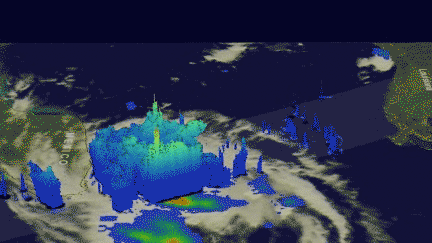
In order for Hermine or any other tropical depression, to intensify there must be a pathway for heat energy from the ocean surface to enter the atmosphere. For Hermine, the conduit may have been one of the two “hot towers” that the Global Precipitation Measurement mission or GPM core satellite observed on Aug. 31 at 4:09 p.m. EDT (2009 UTC).
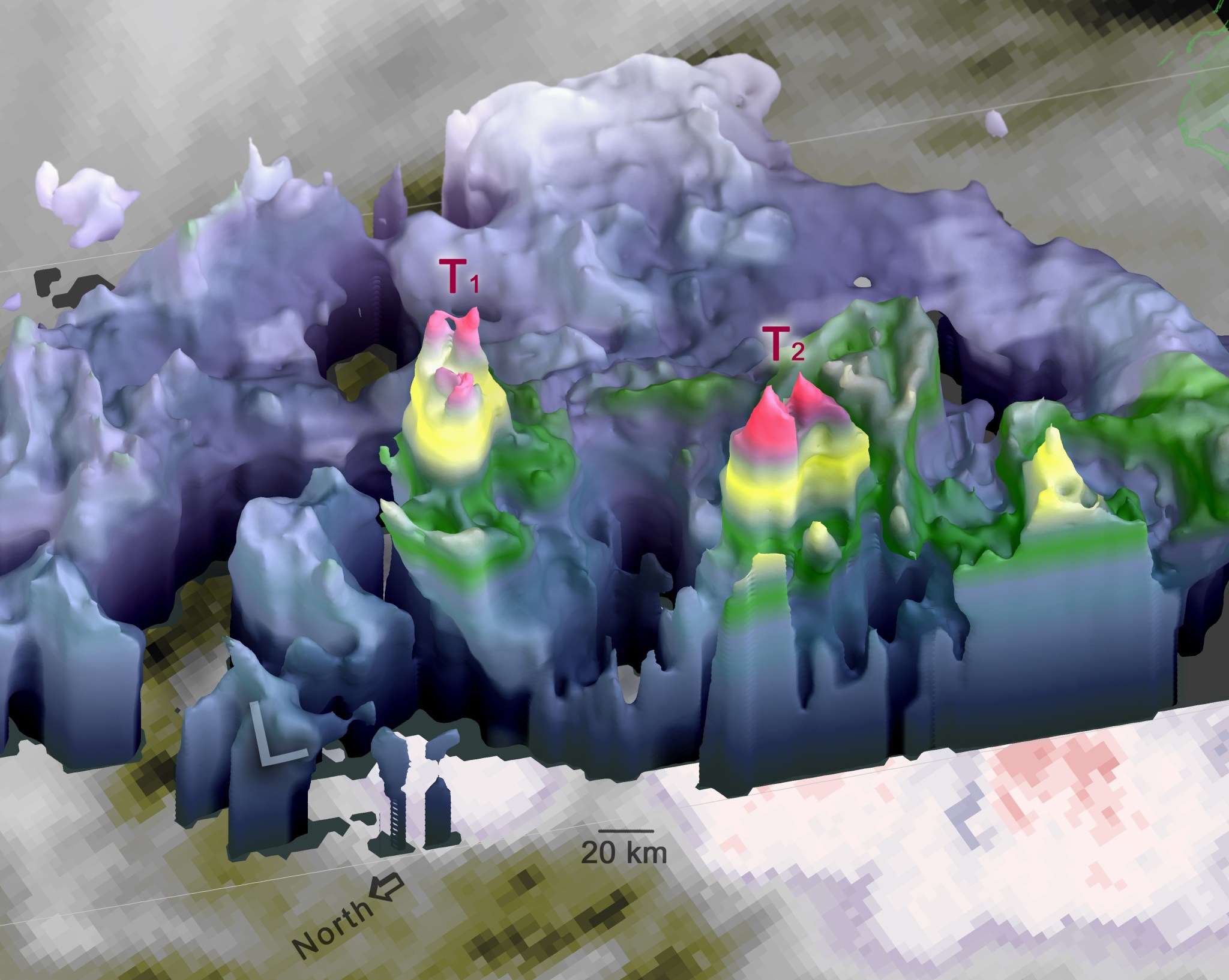
A hot tower is a tall convective cell in which updrafts are strong enough to lift precipitation as high as the top of the troposphere. Updrafts this strong mean that a lot of moisture is condensing in this storm cell as the rain forms. The closer a hot tower is to the low-pressure center of a tropical depression, the more of the heat energy released in that tower is likely to “energize” the tropical depression, leading to a deepening of the low pressure center, and ultimately leading to an acceleration of the winds that circle the low-pressure center.
Two “hot towers” were seen south and east of the center. “One of them was closer to the low pressure center, and so it is more likely to be intimately involved with the strengthening of Hermine,” said researcher Owen Kelley of NASA’s Goddard Space Flight Center in Greenbelt, Maryland who created a 3-D image of the storm using GPM data.
“Repeated observations of cloud-top heights by geosynchronous satellites showed that these two towers were persistent features, lasting approximately 9 to 12 hours, from the evening of Aug. 31 into the morning of Sept. 1. Research performed by NASA scientists suggests that vigorous convection that persists this long can eject enough energy into the atmosphere to influence the fate of hurricanes and other tropical systems,” Kelley said.
The GPM satellite is a joint mission of NASA and the Japan Aerospace Exploration Agency (JAXA).
For more information about GPM, please visit http://pmm.nasa.gov .
Owen Kelley / Rob Gutro
NASA’s Goddard Space Flight Center
Sept. 02, 2016 – Hermine Becomes a Hurricane in the Gulf of Mexico
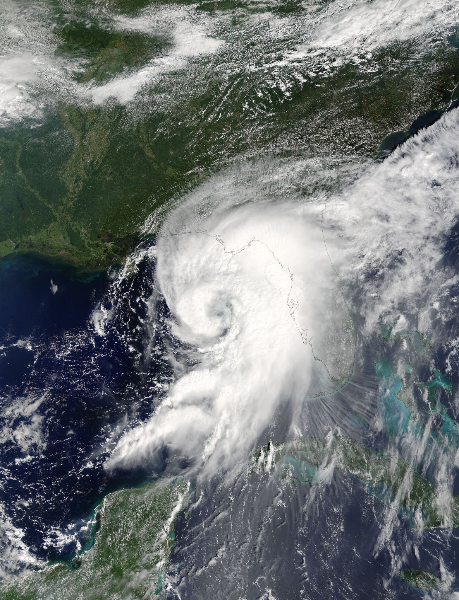
Tropical Storm Hermine officially reached hurricane status on Thursday, Sept. 1, 2016, at 1:55 p.m. EDT. NOAA’s GOES-East satellite captured a visible image of the hurricane at 3:15 p.m. EDT (1915 UTC).
The image shows a much more organized Hermine with bands of thunderstorms wrapping around its low-level center and blanketing the entire state of Florida. The image was created at NASA/NOAA’s GOES Project office, NASA’s Goddard Space Flight Center in Greenbelt, Maryland.
A hurricane warning is in effect from Suwannee River to Mexico Beach, Florida. A hurricane watch is in effect from Anclote River to Suwannee River, and west of Mexico Beach to the Walton/Bay County line.
A tropical storm warning is in effect from Englewood to Suwannee River, from west of Mexico Beach to the Walton/Bay County line, and the Flagler/Volusia County line to Surf City. A tropical storm watch is in effect from north of Surf City to Oregon Inlet, including Pamlico Sound.
At 1:55 p.m. EDT (1755 UTC), the center of Hurricane Hermine was located near 28.1 degrees north latitude and 85.1 degrees west longitude. Hermine is moving toward the north-northeast near 14 mph (22 kph), and this motion with a slight increase in forward speed is expected during the next day or so. On the forecast track, the center of Hermine will be near the Florida coast in the hurricane warning area tonight or early Friday, Sept. 2.
Maximum sustained winds are near 75 mph (120 kph) with higher gusts. Tropical-storm-force winds extend outward up to 185 miles (295 km), mainly to the northeast and southeast of the center.
For updated forecasts, visit NHC’s website at: www.nhc.noaa.gov.
Rob Gutro
NASA’s Goddard Space Flight Center, Greenbelt, Md.
Sept. 01, 2016 – NASA’s MISR Spots Hurricane Hermine Approaching Florida on Sept. 1
On Sept. 1, at 12:30 p.m. EDT, the Multi-angle Imaging SpectroRadiometer (MISR) instrument aboard NASA’s Terra spacecraft passed over the area. his natural-color image from MISR’s vertical-pointing camera shows the large, loosely organized hurricane. Link to story: http://www.jpl.nasa.gov/spaceimages/details.php?id=pia20898
Sept. 1, 2016 – NASA’s GPM Sees Increasingly Organized Tropical Storm Hermine
The Global Precipitation Measurement mission known as GPM found intense storms in Tropical Storm Hermine as it continued to strengthen and organize in the Gulf of Mexico. On Sept. 1 there are many warnings and watches posted along the Florida coast as Hermine is forecast to track toward the state.
Credits: NASA/JAXA, Hal Pierce
Tropical Depression Nine was upgraded to Tropical Storm Hermine on Wednesday, Aug. 31 at 2 p.m. EDT (1800 UTC). The GPM core observatory satellite passed directly above newly designated Tropical Storm Hermine at 4:06 p.m. EDT (20:06 UTC). Rainfall data derived from GPM’s Microwave (GMI) and Dual-Frequency Precipitation Radar (DPR) instruments showed that precipitation intensity had increased and moved into western Florida. Rainfall measured by GPM’s DPR had increased to a rate of over 9.9 inches (251 mm) per hour in very powerful storms in the Gulf of Mexico northwest of Cuba. GPM found these intense storms southwest of Hermine’s center of circulation.
AT NASA’s Goddard Space Flight Center in Greenbelt, Maryland a 3-D image of Hermine was created using GPM data. GPM’s 3-D measurements of some of these powerful storms showed that many storm tops in the Gulf of Mexico were reaching heights above 9.9 miles (16 km). GPM measured radar reflectivity values of over 88 dBZ in some of the most powerful storms. GPM is a joint mission between NASA and the Japan Aerospace Exploration Agency JAXA.
On Sept. 1 NOAA’s National Hurricane Center (NHC) posted a number of warnings and watches. A Hurricane Warning is in effect for Suwannee River to Mexico Beach, Florida. A Hurricane Watch is in effect for Anclote River to Suwannee River, Florida, and west of Mexico Beach to Destin, Florida.
A Tropical Storm Warning is in effect for Anclote River to Suwannee River, Florida, from west of Mexico Beach to Destin and from Marineland to South Santee River, Florida. A Tropical Storm Watch is in effect from north of South Santee River to Surf City, Florida.
At 8 a.m. EDT (1200 UTC), the center of Tropical Storm Hermine was located near 27.1 degrees north latitude and 86.2 degrees west longitude. That puts the center of the storm about 195 miles (310 km) south-southwest of Apalachicola, Florida and about 235 miles (380 km) west-southwest of Tampa, Florida.
The National Hurricane Center (NHC) said that Hermine is moving toward the north-northeast near 12 mph (19 kph), and this motion with a slight increase in forward speed is expected during the next day or so. On the forecast track, the center of Hermine will be near the Florida coast in the warning area tonight or early Friday. The estimated minimum central pressure from a NOAA Hurricane Hunter plane was 992 millibars.
Maximum sustained winds have increased to near 65 mph (100 kph) with higher gusts. Additional strengthening is anticipated, and Hermine is expected to be a hurricane by the time landfall occurs.
For expected conditions in the warning and watch areas, visit the NHC website: www.nhc.noaa.gov.
Harold F. Pierce / Rob Gutro
NASA’s Goddard Space Flight Center
Aug. 31, 2016 – Tropical Storm Hermine Forms in the Gulf of Mexico
Today, Aug. 31 at 2 p.m. EDT, NOAA’s National Hurricane Center upgraded Depression 9 to Tropical Storm Hermine. NOAA’s GOES East satellite captured a visible image of Tropical Storm Hermine that showed the tropical storm organizing in the Gulf of Mexico.
Located roughly 540 miles west of Miami, Florida, Hermine’s maximum sustained winds have increased to near 40 miles per hour with higher gusts. According to the National Hurricane Center, additional strengthening is forecast during the next day or two, and the storm could be near hurricane strength by the time landfall occurs. Hermine is expected to make landfall in Florida’s “Big Bend” area on Sept. 1 with the center of the storm expected to come ashore later that night.
The combination of a dangerous storm surge and the tide will cause normally dry areas near the coast to be flooded by rising waters moving inland from the shoreline. There is a danger of life-threatening inundation within the next 36 to 48 hours along the Gulf coast of Florida from Aripeka to Indian Pass.
Visit the National Hurricane Center for up-to-date watches, warnings, and forecasts.
NOAA Visualization Laboratory
Aug. 31, 2016 – Intensifying Tropical Depression 9 Checked By NASA
Heavy rainfall is a big part of Tropical Depression 9, which is strengthening in the Gulf of Mexico. The Global Precipitation Measurement mission, or GPM, core satellite passed over the gulf in space and measured that rate of rainfall.
The National Hurricane Center (NHC) expects Tropical Depression 9 to intensify over the next day or so. Vertical wind shear is predicted to be low and the tropical depression is moving over warmer water. Both of these factors will provide fuel for intensification.
On Aug. 31 the NHC posted a hurricane watch from Anclote River to Indian Pass, Florida. In addition a tropical storm warning is in effect from Anclote River to the Walton/Bay County line in Florida.
The GPM core observatory satellite scanned the tropical depression on Aug. 31, 2016, at 2:46 a.m. EDT (0646 UTC). GPM’s Microwave Imager (GMI) and Dual-Frequency Precipitation Radar (DPR) instruments saw heavy rainfall in strong convective storms in the Gulf of Mexico northwest of Cuba. GPM’s DPR found that some of these intense storms were dropping rain at a rate of greater than 4.1 inches (105 mm) per hour.
Data from the GPM satellite’s radar (DPR Ku Band) was used to examine the shape of precipitation within Tropical Depression 9. This 3-D examination of precipitation showed that some tall convective storms were reaching heights above 9.9 miles (16 km). Radar reflectivity values of over 52 dBZ were returned to the satellite providing more evidence of the intensity of downpours in the area. Rainfall within the tropical depression supplies additional energy needed for intensification.
That heavy rainfall is one of the things that the intensifying depression is expected to bring to Florida over the next several days in addition to storm surge, tropical-storm-force or even hurricane-force winds, and isolated tornadoes.
The National Hurricane Center said that the depression is expected to produce additional rain accumulations of 2 to 4 inches over western Cuba through today, with maximum storm total amounts up to 20 inches. These rains could cause life-threatening flash floods and mud slides.
Storm total rainfall amounts of 5 to 10 inches are possible over portions of central and northern Florida through Friday, Sept. 2, with isolated maximum amounts of 15 inches possible. Coastal areas of Georgia and the Carolinas are expected to receive storm total rainfall of 4 to 7 inches, with local amounts of 10 inches possible through Saturday morning. These rains may cause flooding and flash flooding.
At 8 a.m. EDT (1200 UTC), the center of Tropical Depression 9 was located near 24.6 degrees north latitude and 88.1 degrees west longitude. That’s about 400 miles (645 km) south-southwest of Apalachicola, Florida and about 420 miles (675 km) west-southwest of Tampa.
The depression is moving toward the north near 2 mph (4 kph). NOAA’s National Hurricane Center said that a north-northeastward motion at a faster forward speed is expected to begin later today, Aug. 31, and a turn toward the northeast is forecast tonight. On the forecast track, the center of the tropical cyclone will approach the northwest Florida coast in the warning area on Thursday afternoon. The estimated minimum central pressure is 1001 millibars.
Maximum sustained winds are near 35 mph (55 kph) with higher gusts. Strengthening is forecast during the next 48 hours, and the depression is expected to become a tropical storm later today, and could be near hurricane strength by the time landfall occurs.
For updated forecasts from NHC, visit: www.nhc.noaa.gov
Harold F. Pierce / Rob Gutro
NASA’s Goddard Space Flight Center, Greenbelt, Md.
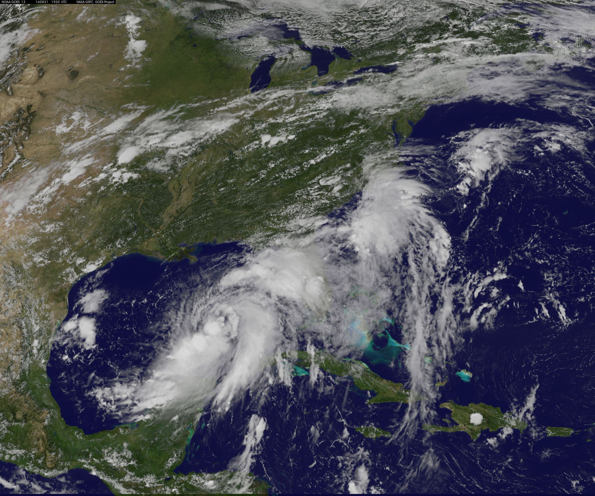
Aug. 30, 2016 – Satellite Sees Large Tropical Depression 9 in the Gulf of Mexico
Although the center of Tropical Depression 9 moved away from Cuba and into the southeastern Gulf of Mexico, western Cuba was still getting drenched from the system. A visible image from NOAA’s GOES-East satellite showed the reach of the large depression.
The National Hurricane Center said at 11 a.m. EDT that torrential rains continue over western Cuba and that a tropical storm watch likely to be issued for a portion of the Florida Gulf Coast later today, Aug. 30.
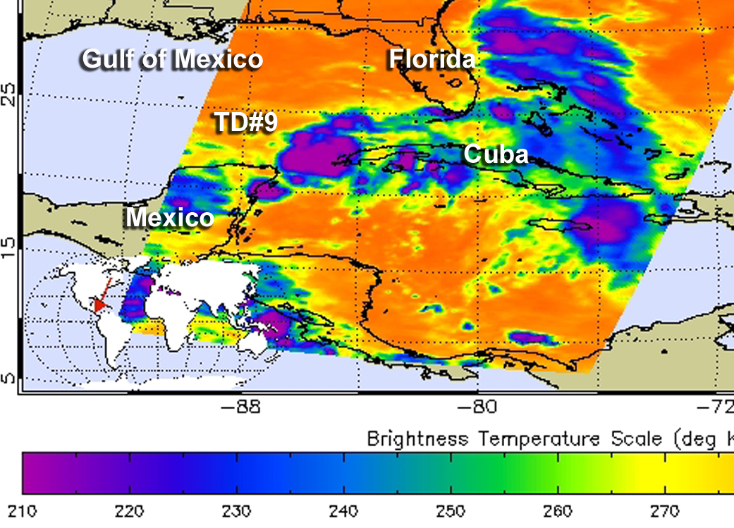
An infrared look at Tropical Depression 9 on Aug. 30 at 3:05 a.m. EDT (0705 UTC) from the Atmospheric Infrared Sounder or AIRS instrument aboard NASA’s Aqua satellite showed that the strongest storms were more concentrated around the center of circulation than the visible cloud imagery showed.
Infrared data takes temperatures, and the colder the cloud tops, the higher they are in the troposphere. Cloud tops around the center of Tropical Depression 9 were as cold as or colder than minus 63 degrees Fahrenheit (minus 53 degrees Celsius), indicating they were high in the troposphere. Storms with cloud tops that cold have been shown to generate heavy rainfall.
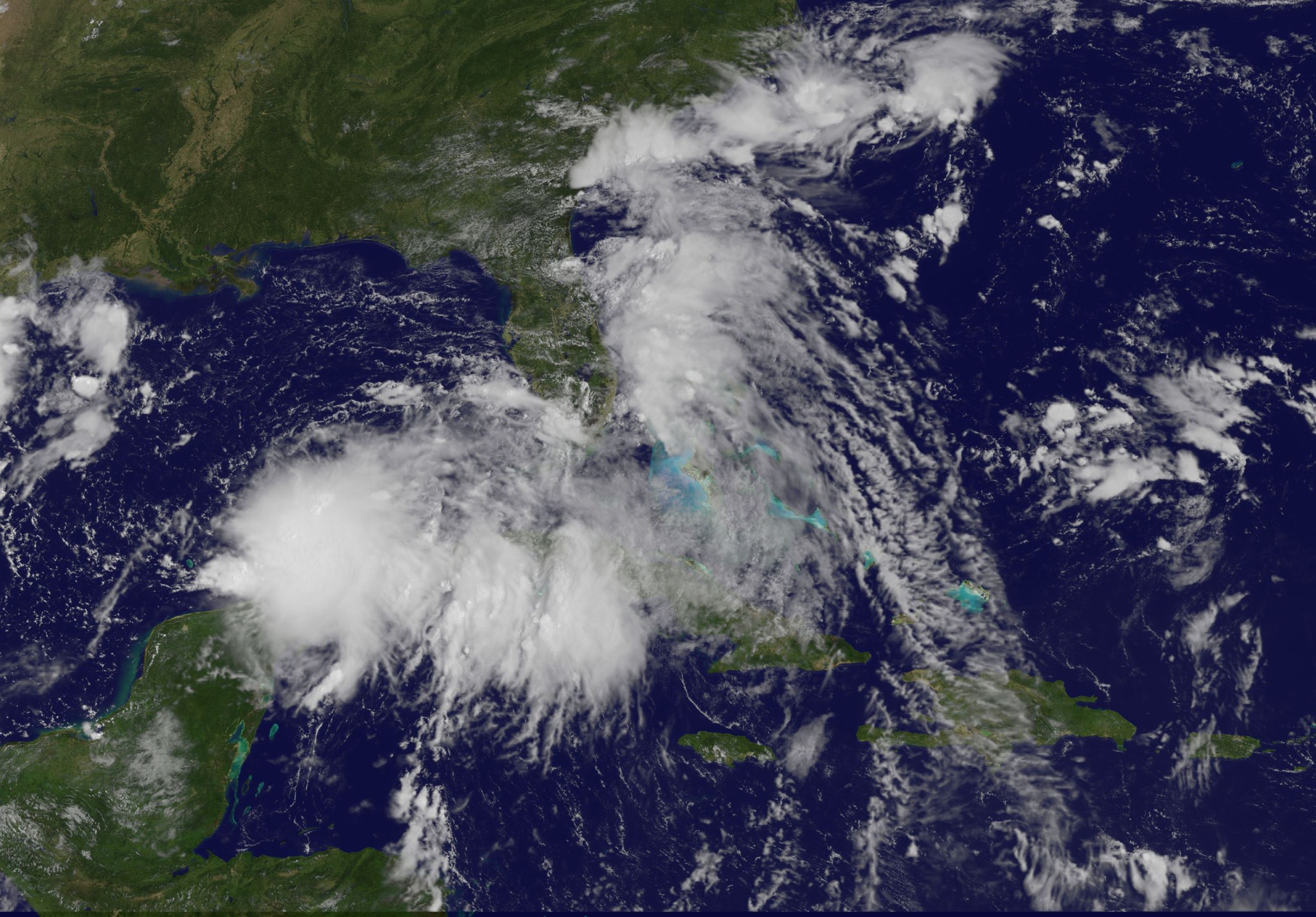
Visible satellite imagery on Aug. 30 at 10:45 a.m. EDT from NOAA GOES-East showed the extent of the large depression. The southwestern extent of the depression’s clouds were over the northeastern part of Mexico’s Yucatan Peninsula, while the northeastern extent of the depression’s clouds stretched over Cuba and the Florida Keys. The GOES image was generated at the NASA/NOAA GOES Project at NASA’s Goddard Space Flight Center, Greenbelt, Maryland.
The National Hurricane Center (NHC) reported at 11 a.m. EDT (1500 UTC), the center of Tropical Depression Nine was located near 24.0 degrees north latitude and 87.2 degrees west longitude. That’s about 340 miles (550 km) west of Key West, Florida, and 310 miles (495 km) west of Havana, Cuba.
The depression is moving toward the west-northwest near 7 mph (11 kph). NHC forecasts a turn toward the northwest is expected later today, Aug. 30, followed by a turn toward the north-northwest tonight. A turn toward the north-northeast is expected on Wednesday. On the forecast track, the center of the depression will continue to move slowly away from western Cuba, and move over the eastern Gulf of Mexico during the next 48 hours.
Maximum sustained winds are near 35 mph (55 kph) with higher gusts. Some strengthening is forecast during the next 48 hours, and the depression is expected to become a tropical storm today.
For updated forecasts, visit the NHC website at www.nhc.noaa.gov.
Rob Gutro
NASA’s Goddard Space Flight Center
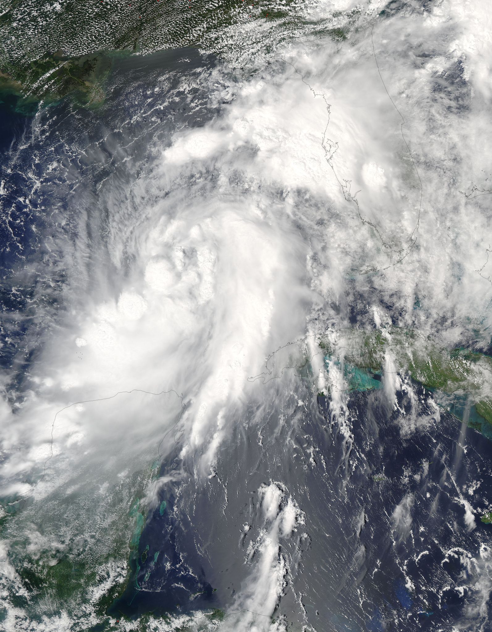
Aug. 29, 2016 – NASA Peers into Tropical Depression Nine in the Gulf of Mexico
The Global Precipitation Measurement mission or GPM core satellite analyzed Tropical Depression 9 after formed in the Gulf of Mexico after a slow crawl over the last week.
The frequency of tropical cyclone formation has definitely increased in the Atlantic Ocean basin. A tropical wave that the National Hurricane Center (NHC) had been monitoring for development since it left the African coast almost two weeks ago was upgraded to Tropical Depression Nine (TD9) on August 28, 2016. The low pressure became a little better organized after moving into the Florida Strait and that led to the upgrade.
Credits: NASA/JAXA, Hal Pierce
The GPM core observatory satellite passed above the still relatively poorly organized tropical depression on Aug. 29 at 2:56 a.m. EDT (0656 UTC). Maximum sustained wind speeds were estimated to be only 34.5 mph (30 knots). Since then deep convection associated with the tropical cyclone has increased. Rainfall measurements within TD9 were derived from GPM’s Microwave Imager (GMI) and Dual-Frequency Precipitation Radar (DPR) instruments. These measurements showed that precipitation was intense in convective storms over the western side of Cuba. GPM revealed that some showers were coming down at a rate of greater than 7.6 inches (193.514 mm) per hour.
GPM’s radar (DPR Ku Band) data were used to examine the 3-D structure of precipitation within storms associated with TD09L. Most thunderstorm tops around the tropical depression were found to reach heights of less than 8.7 miles (14 km). However, GPM’s radar found that some storm tops in powerful convective storms in the Caribbean Sea south of Cuba were pushing up to heights above 9.9 miles (16 km).
At 11 a.m. EDT (1500 UTC) the center of Tropical Depression Nine was located near 23.6 degrees north latitude and 84.3 degrees west longitude. That puts the center about 170 miles (275 km) west-southwest of Key West, Florida and 125 miles (200 km) west-northwest of Havana, Cuba.
The National Hurricane Center (NHC) said that the depression is moving toward the west near 7 mph (11 kph). A turn toward the west-northwest is forecast today, followed by a slow northwestward motion on Tuesday. A turn toward the north is expected Tuesday night. On the forecast track, the center of the depression will be passing north of the north coast of western Cuba today, Aug. 29, and moving farther into the southeastern Gulf of Mexico tonight and Tuesday, Aug. 30. The estimated minimum central pressure is 1007 millibars.
Maximum sustained winds are near 35 mph (55 kph) with higher gusts. Some strengthening is forecast during the next 48 hours, and the depression is likely to become a tropical storm later today or tonight.
The NHC predicts that TD9 will become a tropical storm in the Gulf of Mexico this evening but moderate vertical shear over the next couple days is predicted to keep the tropical depression from significantly strengthening. TD9 is expected to move toward the northwest for a couple days and then made a turn toward the northeast. It is then expected to pass over northern Florida as a strong tropical storm.
For updated forecasts, visit the NHC website: www.nhc.noaa.gov
Rob Gutro / Hal Pierce
NASA’s Goddard Space Flight Center