


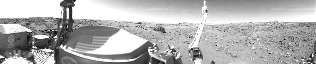
Sand dunes and large rocks are revealed in this panorama of Mars in the first photograph taken by Viking l’s Camera 1 on July 23, having landed on July 20, 1976. The horizon is approximately 3 kilometers (2 miles) away. The late afternoon sun is high in the sky over the left side of the picture. The support struts of the S-band high-gain antenna extend to the top of the picture. The American flags are located on the two RTG (Radioisotope Thermoelectric Generator) wind screens. In the middle third of the picture, the rocky surface is covered by thick deposits of wind-blown material, forming numerous dunes. At the center of the picture on the horizon are two low hills which may be part of the rim of a distant crater. Two very large rocks are visible in the middleground; the nearer one is 3 meters (10 feet) in diameter and is 8 meters (25 feet) from the spacecraft. A cloud layer is visible halfway between the horizon and the top of the picture. The meteorology boom is located right of center. Behind it, the ‘White Mesa’ is visible, which could be seen on the far left side of the Sol O Camera 2 panorama. In the near ground are numerous rocks about 10 cm (4 inches) across, with horseshoe-shaped scour marks on their upwind side and wind tails in their lee. The fine-grained material in front of them contains small pits formed by impact of material kicked out by the Lander spacecraft’s rocket engines.
Image Credit: NASA/JPL