


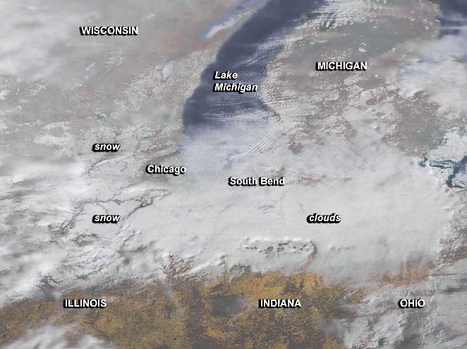
NOAA’s GOES-East satellite captured an image of the snow left behind from the fifth-largest blizzard to hit Chicago on Monday.
A visible picture captured at 1445 UTC (9:45 a.m. EST) showed a large band of snow on the ground in the Great Lakes Region, from west to east, from Iowa through Illinois, passing right through Chicago and east into Indiana.
To create the image, NASA/NOAA’s GOES Project used cloud data from NOAA’s GOES-East satellite and overlaid it on a true-color image of land and ocean created by data from the Moderate Resolution Imaging Spectroradiometer, or MODIS, instrument that flies aboard NASA’s Aqua and Terra satellites.
The National Weather Service (NWS) at O’Hare International Airport reported that 16.2 inches of snow fell in 24 hours, ending February 2. During the storm, the maximum wind speed reached 40 mph at O’Hare. The NWS at Rockford, Illinois reported maximum winds to 43 mph, and a total snowfall of 10.5 inches. Other snow totals included 16.5 inches in Aurora, Illinois and 16 inches in DeKalb, Illinois.
The snow that fell added to the previous snow on the ground, bringing totals to 19.3 inches in Chicago by 6 a.m. Monday, Feb. 2, according to the NWS. NWS noted that it was the city’s fifth largest snowstorm ever.
GOES-East provides visible and infrared images over the eastern U.S. and the Atlantic Ocean from its fixed orbit in space. NOAA’s GOES satellites provide the kind of continuous monitoring necessary for intensive data analysis. Geostationary describes an orbit in which a satellite is always in the same position with respect to the rotating Earth. This allows GOES to hover continuously over one position on Earth’s surface, appearing stationary. As a result, GOES provide a constant vigil for the atmospheric triggers for severe weather conditions such as tornadoes, flash floods, hail storms and hurricanes.
For updated information about the storm system, visit NOAA’s NWS website: www.weather.gov
For more information about GOES satellites, visit: www.goes.noaa.gov/ or goes.gsfc.nasa.gov/