


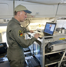
 Senior research scientist John Sonntag of URS Corp. at NASA’s Wallops Flight Facility in Virginia checks out the functioning of the Airborne Topographic Mapper mounted in NASA’s DC-8 airborne science laboratory prior to a checkout flight for the 2010 Arctic IceBridge mission. (NASA photo / Tom Tschida) PALMDALE – NASA’s Operation IceBridge mission, the largest airborne survey ever flown of Earth’s polar ice, kicks off its second year of study when NASA aircraft arrive in Greenland March 22.
NASA’s DC-8 airborne science laboratory is scheduled to depart the Dryden Aircraft Operations Facility in Palmdale, Calif. for Thule, Greenland, March 21. Scientists and flight crew will fly about 10 to 12 science missions over the Arctic over a five-week period. The first priority is to survey Arctic sea ice, which reaches its maximum extent each year in March or early April. High- and low-altitude flights also will survey Greenland’s ice sheet and outlet glaciers.
The IceBridge mission allows scientists to track changes in the extent and thickness of polar ice, which is important for understanding ice dynamics. IceBridge began in March 2009 as a means to fill the gap in polar observations between the loss of NASA’s Ice, Cloud and land Elevation Satellite, or ICESat, and the launch of ICESat-2, planned for 2015. Annual missions fly over the Arctic in March and April and over Antarctica in October and November.
“NASA’s IceBridge mission is characterizing the changes occurring in the world’s polar ice sheets,” said Tom Wagner, cryosphere program manager at NASA Headquarters in Washington. “The mission’s goal is to collect the most important data for improving predictive models of sea level rise and global climate change.”
Researchers plan to resurvey previous flight lines and former ground tracks of ICESat while adding new areas of interest. Scientists also will target some areas that have been undergoing mysterious changes. The major glaciers in southeast Greenland once thinned simultaneously, but some of those glaciers have been thinning at an accelerated rate – as much as 40 feet per year – while others have thickened. And glaciers in northwest Greenland, once a stable region, have mostly begun to thin.
In preparation for approximately 200 science flight hours during the spring 2010 campaign, engineers have been outfitting NASA’s DC-8 aircraft with an array of science instruments. In mid-April, the engineers will transfer the science instruments to the smaller, more maneuverable P-3B aircraft. The crew will spend May making another 10 to 12 science flights from Kangerlussuaq and Thule, Greenland.
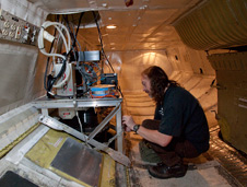 David Rabine of NASA’s Goddard Space Flight Center checks out the installation of the Laser Vegetation and Ice Imaging Sensor mounted in the belly of NASA’s DC-8 airborne science laboratory prior to embarking on the 2010 IceBridge mission to survey the Arctic polar ice pack. (NASA photo / Tom Tschida) Both aircraft will carry the Airborne Topographic Mapper, or ATM – a laser altimeter similar to those on ICESat. ATM measures changes in the surface elevation of the ice by reflecting lasers from the ground back to the aircraft and converting the readings into elevation maps. Another laser altimeter, the Land, Vegetation, and Ice Sensor, operates at higher altitudes and can survey larger areas quickly.
The spring flights are led by project scientists Lora Koenig of NASA’s Goddard Space Flight Center in Greenbelt, Md., and Michael Studinger of Goddard Earth Science and Technology Center at the University of Maryland. The mission also includes scientists, crew and technicians from Goddard, Wallops, NASA’s Dryden Flight Research Center in Edwards, Calif., NASA’s Ames Research Center in Moffett Field, Calif.; The Earth Institute at Columbia University in Palisades, N.Y.; the University of Kansas; and the University of Washington.
The versatility of the planes will allow some new observations not currently possible from satellites. Radar instruments from the University of Kansas and a gravimeter from Columbia University will allow scientists to “see” snow, ice, and bedrock characteristics at depths below the surface. Such information will enhance our understanding of glacier and ice sheet processes and will help scientists predict a glacier’s future behavior.
“NASA has a unique capability to look at these things from a bird’s-eye perspective, not only from space but also from multiple long-range, high performance aircraft,” said John Sonntag, a senior scientist with URS Corporation in Wallops Island, Va., and member of the IceBridge management team. “If not for IceBridge, the global science community and the public would miss out on a great deal of knowledge about Greenland and Antarctica.”
For information about the IceBridge mission, visit: https://www.nasa.gov/icebridge
NASA Television will air a video file about the IceBridge mission. For NASA TV downlink, schedule and streaming video information, visit: https://www.nasa.gov/ntv
For more information about NASA Dryden Flight Research Center and its research projects, visit: https://www.nasa.gov/centers/dryden
– end –
text-only version of this release
To receive status reports and news releases issued from the Dryden Newsroom electronically, send a blank e-mail message to dfrc-subscribe@newsletters.nasa.gov. To unsubscribe, send a blank e-mail message to dfrc-unsubscribe@newsletters.nasa.gov. The system will confirm your request via e-mail.
Sonja Alexander
Headquarters, Washington
202-358-1761
sonja.r.alexander@nasa.gov
Sarah DeWitt
Goddard Space Flight Center, Greenbelt, Md.
301-286-0535
sarah.l.dewitt@nasa.gov